


Tsho Rolpa (also known as Cho Rolpa) is one of the biggest glacial lakes in Nepal. The lake, which is located at an altitude of 4,580 metres in the Rolwaling Valley, Dolakha District, has grown considerably over the last 50 years due to glacial melting in the Himalayas. In Sherpa language “Tsho” means Lake, and “Rolpa” means Rolwaling valley. The Rolwaling Valley itself is renowned for its stunning mountain vistas, with majestic peaks such as Gauri Shankar (7,145 meters) and Melungtse (7,181 meters) dominating the skyline. The valley is also home to several glaciers and pristine alpine lakes, including the mesmerizing Tsho Rolpa.

Tsho Rolpa lies in Gaurishankar Conservation Area which is a protected area in the Himalayas of Nepal that was established in January 2010, covering 2,179 km² in the Ramechhap, Dolakha and Sindhupalchok districts and encompassing 22 Village Development Committees. It is contiguous with Tibet in the north.
Dolakha is a district that is quite familiar due to its natural and religious attractions. Dolakha is commonly known among the Nepali people for the names of Bhimsen and Kalinchowk Temple. It holds religious significance for the people’s faith in Nepal. Along with that, many other places within Dolakha, such as Jiri, are also well-known among everyone. However, limiting the introduction of Dolakha to just a few aspects would be unjust. This district, spreading over approximately 2191 square kilometers, has a lot more to offer. If you observe Dolakha closely, you will discover numerous things. Gaurishankar Mountain can be seen, which tells the time in Nepal.
Rolwaling is surrounded by majestic Himalayan ranges such as Takargo, Parichamo, Numbur, Linku, Kang Nachugo, Drangnag Ri, Dingiung Ri, Chobuje, Chokigo, and Bamongo. Additionally, there is a beautiful lake known as Tsho Rolpa Lake located in the Rolwaling Valley, which is estimated to have formed around 50 years ago. This lake, with an area of 1.65 square kilometers, is a unique example of natural beauty, with a depth of 135 meters. It is Tsho Rolpa and Dolakha, located at an altitude of 4,580 meters above sea level, and it is featured in Season 3 of “Heaven is Myth, Nepal is Real.”
The journey from Kathmandu to Charikot on the first day always starts from the outskirts of Kathmandu, passing through the widened road. Leaving Bhaktapur behind, the journey proceeds towards Dhulikhel, with stops at Koteshwar, Thimi, Sallaghari, and Suryabinayak. Although the weather was clear, we anticipated the challenges of rainfall during the upcoming monsoon season and accepted them wholeheartedly as part of our journey. We avoided huge traffic congestion on the road in the early morning hours. After a journey of approximately 30-40 minutes, we finally reached Dhulikhel.
Dhulikhel, located in the Kavrepalanchok district, has been a beautiful destination established for the refreshment of nearby residents for many years. It is set up as a scenic destination, especially for the people living in the vicinity, to celebrate Fridays. The central location of the district also offers a stunning view of the Himalayan ranges, making it suitable for short hikes. Moreover, it provides excellent arrangements for comfortable stay. Due to its proximity to Kathmandu, this area has gained significant popularity among tourists and has become well-known for its tourism appeal.

After leaving Dhulikhel on the Arniko Highway, we reached Zero Kilometer. From there, taking a right turn, we continued towards Dolalghat. While on the way, we caught a glimpse of the Dolalghat Bridge from a certain point. Witnessing the majestic Indrawati River flowing continuously beneath the welcoming and unique Indravati Bridge filled our hearts with joy. Additionally, the sight of the beautiful waterfall, created due to the rainy season, added to the scenic beauty of the area. Due to the onset of the monsoon season, we also witnessed a stunning and picturesque flowing river.
Dolalghat is the confluence of the Indrawati and Sun Koshi rivers. Located at an altitude of 650 meters above sea level, Dolalghat attracts people for rafting adventures on the Sun Koshi river. Our team, leaving behind the bustling Dolalghat, continued to move forward towards Khadichaur.
Khadichaur is a major commercial center in Sindhupalchok district, well-known for its trade activities. It serves as a significant trade route connecting Nepal with China, and travelers heading towards Tatopani, a major trading point with China, have to pass through Khadichaur. Due to its role in connecting the country with a major trade route, Khadichaur has also witnessed significant development in terms of commercial activities.
After having a meal at Khadichaur, our journey proceeded towards the headquarter of Dolakha, Charikot.
After crossing the Khadichaur Bridge, which connects Dolakha and Sindhupalchok, we continued our journey towards Charikot. As we moved ahead, the Sun Koshi River flowed alongside, gradually fading away. For a moment, there was a sense of emptiness as we observed the deserted Sun Koshi River. However, the beauty of the winding road, embraced by hill winds and dense forests, made us forget about that emptiness. It was a continuous series of experiencing the surroundings and immersing ourselves in the journey.
The road that connects Khadichaur to Charikot falls under the Lamoshanghu – Ramechhap Highway. With the support of the Swiss government nearly 40 years ago, improvements were made to the road section from Khadichaur to Charikot. As a result of the recent road expansion work, the road has now become much smoother and easier to traverse.
After the ascent, we witnessed some distinct views from Khadichaur. The road winding through the hills had a picturesque scenery with trees lining its sides. The coolness of the mountain breeze was refreshing. As we continued our journey, we came across small settlements along the way. In those villages, we saw some people going about their daily activities. Young boys and girls were walking together, returning from school, while in the nearby jungle, some women were carrying heavy loads of firewood on their backs. It was a day when we were travelers, venturing out from our homes for the purpose of the journey. The villagers, on the other hand, seemed accustomed to a life of travel and exploration.

Although roads have been constructed in most places, some road sections are still under construction. Depending on the time, there are times when the road is muddy, times when there are gravel sections, and times when the road is flooded and needs to be crossed carefully. Despite these challenges, the journey continues forward towards Charikot.
We arrived in Charikot during the cool weather of the evening. It was transforming from a day to a night. When we reached Charikot, the bluish sky during the day was covered completely, turning it white. The wind was blowing gently, the sky was darkened making it feel like rainfall is near.
When we explored Charikot on the second day, it wasn’t fully awake yet. The sun was hidden behind the clouds, and the houses located a few meters away were not clearly visible. As the morning dawned, we eagerly brought liveliness to the city. Even though the day wasn’t fully clear, people had to wake up and do the necessary work.
While we were preparing for our journey, Charikot was busy with its daily preparations. People were already engaged in their daily tasks, making the city lively. Karate learners were running in the market from the early morning. Traders were unloading goods from their trucks. And the sweet shop owner was busy arranging jalebis in stacks with the help of a diligent worker. Witnessing the morning hustle and bustle of Charikot, we were enchanted. Charikot, situated at an elevation of 1554 meters above sea level, enticed us that morning, making the day all the more exciting.
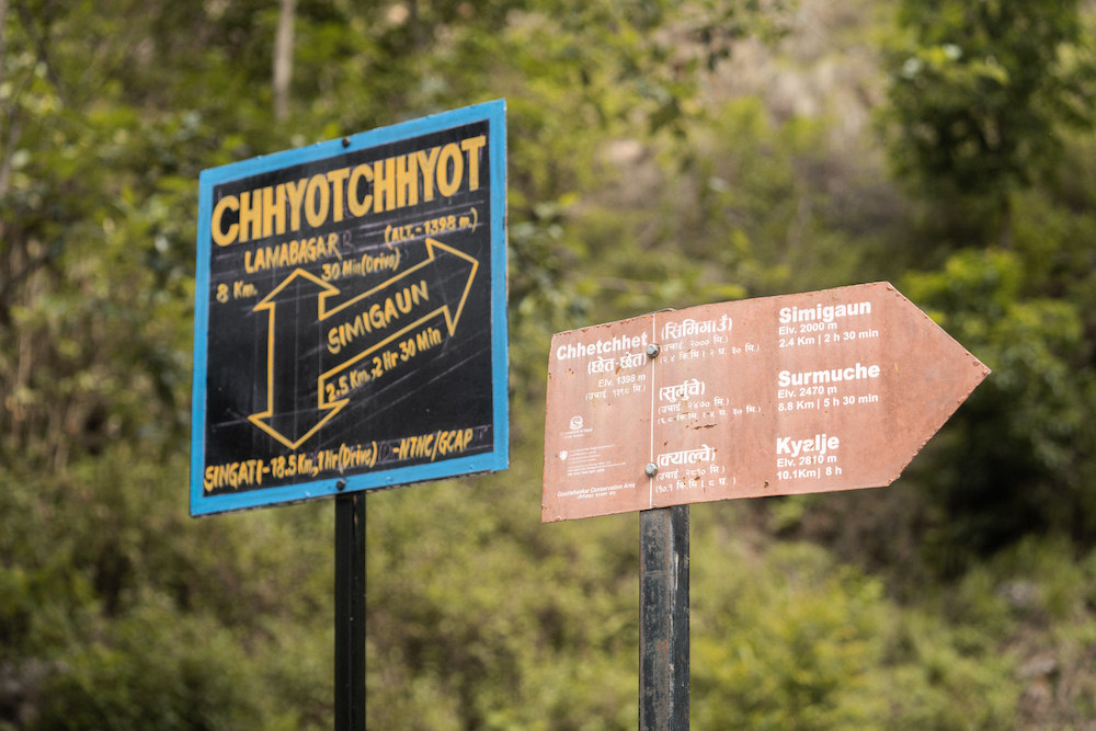
As we moved towards Chechet from Charikot, the hustle and bustle didn’t fade away. On the previous day, we had traveled 130 kilometers from Kathmandu to reach Charikot Bazar, and on that day, we covered an additional 50 kilometers to reach Chechet. Due to the presence of the ancient and immensely revered Bhimeshwar Temple in Dolakha, Charikot is also known by the name Bhimeshwar. It is believed that sweating while inside the temple’s premises is considered a sign of impurity, and many people experience profuse sweating when visiting the temple. This is seen as an indication of purging past impurities within oneself and the country as well. Situated in the heart of Dolakha, the Bhimeshwar Temple holds significant religious and historical importance, being recognized as the guardian of the nation of Nepal. Setting foot on such sacred land is, in itself, a religious achievement.
Foggy weather accompanied us throughout the day. As we moved from Charikot towards Dolakha Bazaar, we embarked on a new journey. With every new road, our excitement doubled. The places we hadn’t visited before were like sweet gifts for the people who had never left those areas. Every turn was new, every alley was new, the forests were new, the wind was new, new art, new culture, new landmarks, and even the geography was new. A traveler embraces all these curiosities, never getting tired of the passage of time. As we ventured towards Chechet, we too felt the same. A sense of novelty had settled in our hearts. This exploration of novelty created a sense of home in our minds, as if we had built a house within ourselves.
As we reached a certain point, we heard the sound of a small stream. There, we witnessed a glimpse of the beauty of the hills. The sky, which had been clear since morning, gradually turned dark. Even though the journey wasn’t long, we still had the fear of getting drenched by the rainfall. The darkened clouds made us fear more.
After a short conversation with the locals, we moved forward. Although the weather had become intense, demanding some rest time, we kept on moving though the clouds in the sky were turning into enemies.
No matter how the weather was, the path itself felt easier than we had anticipated. During the scorching hours of the day, as the sun rays filtered through the branches, the glimmer of the sun on the road appeared remarkably beautiful. These thoughts played in our minds throughout the journey. However, in the end, the rain starts falling.

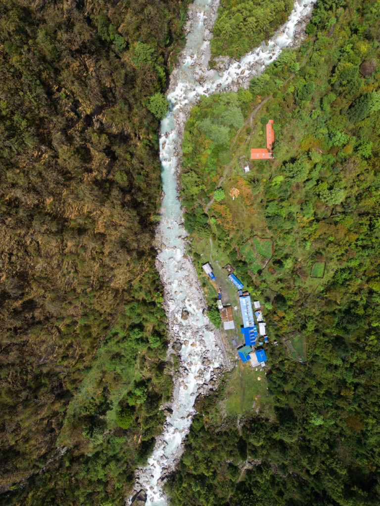
After resting while in Suti Bazar the rain stopped. We took that opportunity and we continued forward towards Chet Chhet. After a few kilometers of travel, the weather also cleared. The dry road allowed us to reduce the remaining distance by a few kilometers. There was the continuous flow of the Tamakoshi River beside.
The Tamakoshi River is a large river that flows from Tibet towards Nepal. Although the literal meaning of Tamakoshi is “River of Copper,” it is known as the “River of Sorrow” due to the tragic stories associated with it. It is said that during the reign of King Rana Bahadur Shah, families affected by an epidemic in Kathmandu were relocated to the banks of the Tamakoshi River. In the attempt to save the city, young Newar children were sent to live in the caves near the river, where they suffered from the effects of the epidemic. Sitaramjyu, a deity revered by the Newar community, is believed to have provided solace to their lamentation, describing their grief. It is for this reason that the river came to be known as the “River of Sorrow” in history.
The Gaurishankar Conservation Area begins from Sigati. Gaurishankar Conservation Area is a designated protected area declared by the Government of Nepal through a notice published in the Royal Gazette on the 27th of Push 2066 (January 10, 2010). This conservation area borders Sagarmatha National Park in the east, Langtang National Park in the west, and touches the Tibetan region of China in the north. In this conservation area, which is in a trans-Himalayan region, there are various species of animals and birds, including the endangered Snow Leopard, Musk Deer, Himalayan Tahr, Red Panda, Clouded Leopard, and various reptiles. There are 34 species of mammals, 235 species of birds from 37 families, 16 species of fish, 9 species of amphibians, and 14 species of snakes. Traveling in this area, which is rich in natural and biological diversity, is considered fortunate by every traveler. With this sentiment, we also feel connected and blessed.
After enduring the fatigue of the entire day, we gradually reached the village. Once we had refreshed ourselves with a hot meal, we left the village behind and headed towards the waterfall.
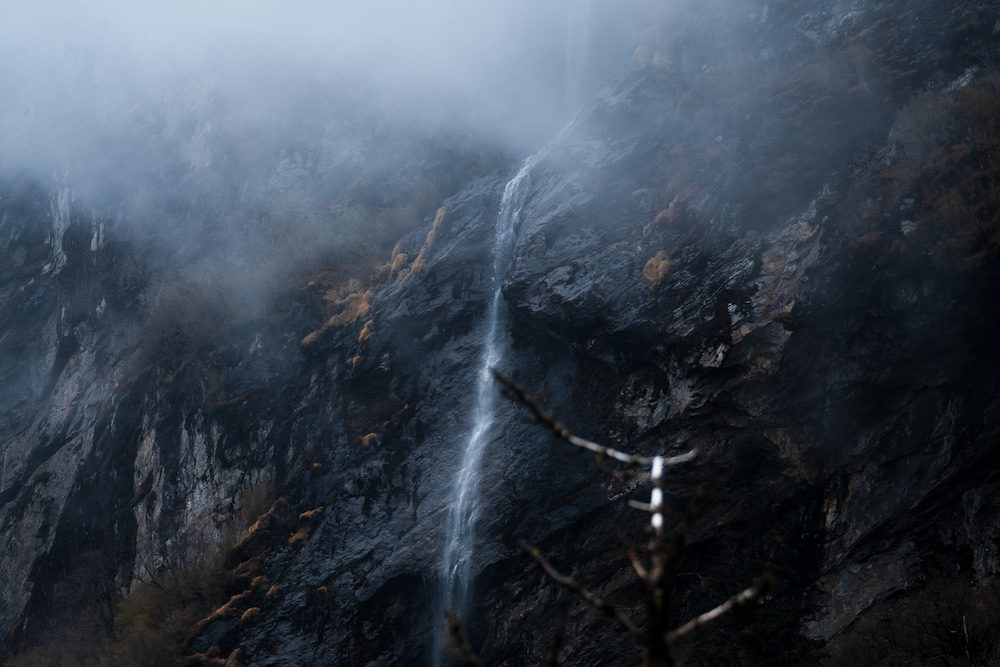
The distant waterfall, located not far from the village, continuously cascaded down from the midst of a large cliff. The sparkling waterfall, originating from the peak of the mountain, had a unique sweetness in its sound. Even in the echoing voice that reached the village, we found tranquility. As we approached the waterfall, the cool splashes of water refreshed our bodies, and made us want to swim. We spent some time splashing in the rejuvenating water, relieving the fatigue from our bodies.
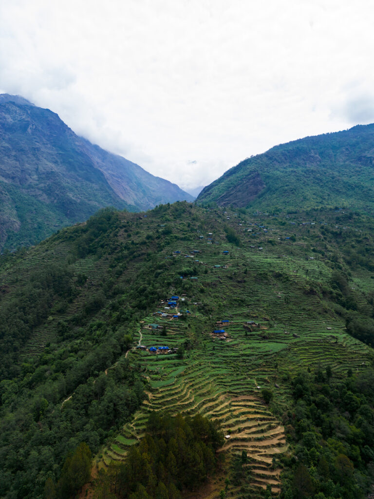
Chetchet is a small Tamang village in Gaurishankar Conservation Area houses This village is situated approximately 1380 meters above sea level on the banks of the Tamakoshi River, and it consists of around 50 to 60 houses. Alongside the development of tourism, hotels have recently been established in this area. Currently, tourism has brought significant economic opportunities to this place. Apart from tourism-related businesses, the locals also engage in rearing livestock, including goats and local poultry. As the starting point of the Chho Rolpa trekking trail, this area will witness a rapid increase in tourism, especially during the upcoming days.
The journey towards Simigaon begins by hiring a porter and setting off. The sight of the restless Tamakoshi River outside the valley fills us with excitement. As the journey commences, we cross a beautiful suspension bridge that sways over the gushing waters. The water beneath the bridge possesses a golden hue that mesmerizes us. Leaving the bridge and the river behind, we continue along a steep trail. The path is well-organized for trekking.
Even as we approach further, the sound of the rushing stream continues to resonate in our ears. The presence of fragrant air flowing through the jungle path adds to the ambiance. It has the power to captivate and ignite a sense of romance within.
Amidst the evergreen forests, the path remains untouched as we embark on our adventurous journey. Along the ascending path towards Simigaun, travelers can spot designated resting spots created.
Simigaun, a beautiful village situated at an altitude of 1,771 meters above sea level, is nestled in the foothills of the majestic Hills. With a population of around 300 to 400 people and approximately 200 households primarily inhabited by Tamang and Sherpa communities, agriculture, particularly potato and maize farming, is the main source of income in this region. Recently, tourism has also had a positive impact on the economic development of the area.
During clear weather, one can catch a breathtaking view of the Gauri Shankar Himal from this location. However, due to the geographical challenges posed by the surrounding hills, there are issues with mobile network coverage, which is a common problem in rural areas across the country. Nevertheless, Simigaon stands out as a place where Nepal Telecom’s (NTC) network works well, at least until Beding.
It is essential to stay connected with your fellow travelers for safety reasons during the journey. Nepal Telecom has made efforts to provide network coverage in this region, although it may still be more crucial for local residents than short-term visitors
The network provided by Nepal Telecom, extending from urban to rural areas, is crucial in bridging the gap and connecting rural households with the world. It has been instrumental in providing convenience to rural areas by fulfilling the need for support and connecting them globally. It is hoped that in the coming days, various rural regions of Nepal will also receive expanded services in the form of infrastructure and the rural lifestyle will become even more accessible.
The journey from Simigaun towards Kyalche was more memorable because of the natural beauty of the place. There was a terrifying gorge below and above, there is a small but beautiful suspension bridge. For a moment, we were captivated by the enchanting scenery, capturing it in our eyes, and feeling the thrill within us.
As we began the journey towards Tsho Rolpa, we were greeted by the sign of a roaring river. Wherever we went, the river was by our side. In order to break the monotony of the continuous flow, we came across a suspension bridge at certain intervals. It too had its own charm, offering a fresh experience every time.
There was another beautiful aspect of the journey, the melody of the river. As we walked along the trail created by the river’s edge, we had to listen to the sound of the river throughout the day. Sometimes, as we continued walking, our feet stepped in sync with the rhythm of the river’s sound. We felt connected to nature to such an extent.
Pictures depicting road signs on the rocks have been created for the convenience of travelers. Looking at those pictures, we were able to proceed on our journey with ease. Sometimes, we came across steep and narrow paths. Our tired bodies felt some relief as we leaned against the rocks. And then, we continued our journey, climbing uphill and descending downhill. It took quite some time to reach our destination even when we were making progress.
There was a signboard at Uttise indicating that the journey would be long and tiring. After a journey of about one and a half hours only we would reach our destination, Surmuche. We noticed that the body tired from the morning’s trek was still carrying fatigue, but we had the enthusiasm to overcome the exhaustion and move on to new places. With the support of that enthusiasm, we continued our journey without interruption. However, we also encountered some difficulties that made our journey even more challenging because of rain.
The morning dawned with a delightful charm at an elevation of 2,480 meters above sea level. We could see the majestic peaks and the pristine mountains all around. The melodious sound of birds blended with the sweet rhythm of the stream, and the cool breeze touched our ears, creating a sense of tranquility. Despite the clear weather, our spirits were high with enthusiasm.
Even in the morning, we had access to the NTC network on our mobile phones. Taking advantage of this opportunity, everyone called their homes and made plans for the day.
There is only one hotel in Surmuche,, and it was built just a year ago. From dawn till evening, we can only reach this hotel by walking slowly. If you arrive at Chet Chet on the first day of your journey before 12 o’clock, you can reach Surmuche on that very dayl. But the longer you extend your journey, the more memorable and comfortable it becomes. The rest is up to your own thoughts and considerations.
When we embarked on the journey from Surmuche, the sun was shining brightly above us. The morning sun was scorching as we entered the path through the jungle. The rays of sunlight filtered through the leaves and filled the path. The ground dampened by the previous day’s rain welcomed us into the wilderness.
The porter also accompanied us that day. It was a delightful experience for the young traveler to be able to drink water directly from the streams, flowing through the gorges. This aspect of the journey becomes a blessing and a precious memory for the trekker, as it saves them from the hassle of carrying water along the trip.
After leaving Ketang river, the journey continues towards Dongang. We move ahead, leaving behind other streams and bridges on the path. After a continuous trek, we reach the Kyalche at an altitude of 2810 meters.
According to the signboard placed on the trail, it takes only 45 minutes to reach Dongang from Kyalche. However, we took a little more time. Just like Surmuche, there is only one hotel in Kalche as well. Travelers who come for the journey can find good food and accommodation arrangements at this place.
The clear weather in the morning changed drastically as we moved a little further from Kyalche, it started to rain lightly.
After putting on raincoats, we resumed our journey. However, it was a bit uncomfortable to walk with the raincoats on. Despite the discomfort, we persevered and continued our efforts to get closer to Dongang.
When we reached Dongang to have our meal, we were mesmerized by its beauty. There was a golden gate at the entrance and only three houses on the shore. During our entire Tsho Rolpa trekking journey, that day’s scenery was the most beautiful we had seen. The beauty of Dongang, with its tranquil Rolwaling River flowing by, captivated us and created an enchanting and magical atmosphere.
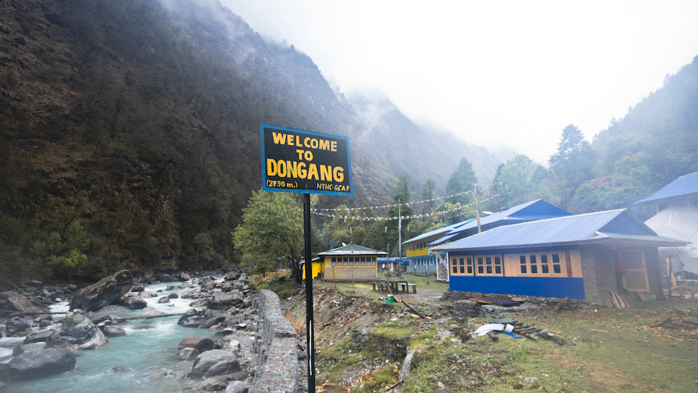
In the morning, we witnessed an even more beautiful view of Dongang. The weather had cleared up, and the mountains had revealed their majestic presence with their snow-capped peaks. The sight of the mountains uplifted the spirits of the trekkers with a renewed sense of enthusiasm. Despite the rainy journey the day before, we hadn’t lost our determination to continue trekking. The journey had been long, but our bodies were adapting and easily coping with the trek.
The rays of the morning sun spread across the sprawling hills, illuminating them. We were eager to embrace the new day. We set out to enjoy the free flowing river while our breakfast was being prepared.
Having witnessed the beauty of Dongang, situated at an altitude of 2,700 meters above sea level, perhaps fate had also destined us to spend a night there. Even as we left Dongang in the morning, the desire to spend another night there lingered in our hearts.
We crossed Dongang and moved ahead towards Beding.
Even after spending three days on the journey, we hadn’t seen the majestic mountains clearly. With a desire to see the enormous Himalayas ahead, we walked with eager anticipation. The porters chatted with us as we continued walking behind them.
We crossed several bridges while walking. We left the bridges behind. The uphill climb was always with us. We shared sweet moments of life with our companions and continued towards our destination.
We descended through the rays of sunlight piercing through the canopy of trees. The scent of the dew reached our noses. The path was uneven due to the rocky steps. There were risky wooden tree’s bridges which were difficult to cross, so we had to balance ourselves. After a short journey, we saw the Himalayas towering above the mountains. The exhausted body was rejuvenated by that scene alone.
The Himalayas are an enchanting sight. Once a person has seen the Himalayas up close, they are constantly beckoned by their allure. When we reached Theplung, we experienced this phenomenon firsthand.
As we descended towards Thangding from Theplung, the scorching sun was directly overhead. The heat of the warm sun was tempered by the wind that touched the forest and the river. The river that had accompanied us from the first day was still there. We were chasing its source until we reached Tsho Rolpa.
Following the river is a spiritual experience. Listening to the story of it flowing from the source gives a different perspective on life. We also compared our life with the river for a while. It inspired us to look at both the purpose and the past.
When we reached the Thangding village, we were quite hungry. We called them to prepare food before setting out in the morning, so when we arrived, the cooked meal was ready. It’s convenient to have a hotel contact in Thangding because even in this remote location, there is a Nepal Telecom tower, allowing us to easily make arrangements. Having a mobile network that works in this secluded area of the mountains has been a great support for both travelers and locals. Throughout the day, when the network was available, we were able to stay connected to some extent. Fortunately, upon reaching Thangding, we were able to make a phone call back home.
At an altitude of 3,344 meters above sea level, Thangding is the only village, and it’s a serene place. People who come here can call directly from Surmuche for food upon arrival. However, there is still no solution to the fatigue that comes from climbing uphill.

After heading towards Beding from Samadar, a wave of excitement surged within us. It was exhilarating to know that the destination was just a two-hour hike away. At an altitude of 3,415 meters above sea level, the change in geography became apparent after leaving Samadar. We enjoyed the magnificent view of a giant waterfall, the Himalayas, and beautiful mountains. It filled our heart with joy and contentment throughout the journey.
The weather turned bad again. We have been facing rainfall since day 2. Despite knowing about the challenges brought by the monsoon journey, We had hoped that we would escape the rain. But our wish remained unheard by nature.
Fog covered the entire landscape with mountains and the Himalayas, gradually enveloping the weather with a sense of melancholy. We had heard that Beding is the district of climbers, and behind that lies intriguing facts. Until now, 65 individuals from this place have successfully scaled the world’s highest peak, Mount Everest. Witnessing such brave and hardworking individuals born in this land throughout our journey left our eyes filled with excitement and admiration.
Beding, located during Tsho Rolpa’s journey, had around 80 households, making it the largest settlement we had seen during our trek. Upon reaching there, we became aware of the Sherpa community’s abundance, with approximately 400 residents there, and most of them are engaged as mountain climbing guides and porters, actively working in various parts of the country. Among these residents, there were 65 individuals including 6 women, who had successfully summited Mt. Everest. Hearing about their accomplishments filled us with a sense of pride as well.

When we reached the village of Beding, located at an altitude of 3709 meters above sea level, we were fascinated by the unique dialect spoken in the village. In the past two days, we had only encountered a limited number of people, but on that day in Beding, we witnessed a large and vibrant community. We observed the Sherpa culture and experienced a lively village that captivated our eyes. It was a thriving village that brought life to our journey.
The village of Beding is connected to the world through a single medium, which is the recently constructed tower of Nepal Telecom. Through this tower, Nepal Telecom has established BTS (Base Transceiver Station) and operates GSM mobile services in the Dolakha district’s Beding. Approximately five hundred households in this area benefit from Nepal Telecom’s service, along with the tourists who visit this region. Despite the high investment and low returns, Nepal Telecom has successfully completed this project, making a significant contribution to the country’s development. During times of illness or emergencies when access to health services and communication is crucial, this tower provides assistance to the residents of Beding.
In the lap of nature, the Rolwaling River was flowing nearby, the smoke rising above every household, and the Sherpa community, followers of the Buddhist faith. For us, both the geography and way of life in that place were new. The Buddhist monasteries were new, the layout of the settlement was new, the symbols were new, and the laughter echoed by the symbols was new. In order to enhance this newness, the towering Himalayas stood firm in the background, adorning themselves with a white garland of snow, observing Beding like a vigilant sentinel. It was a captivating sight that touched the heart.
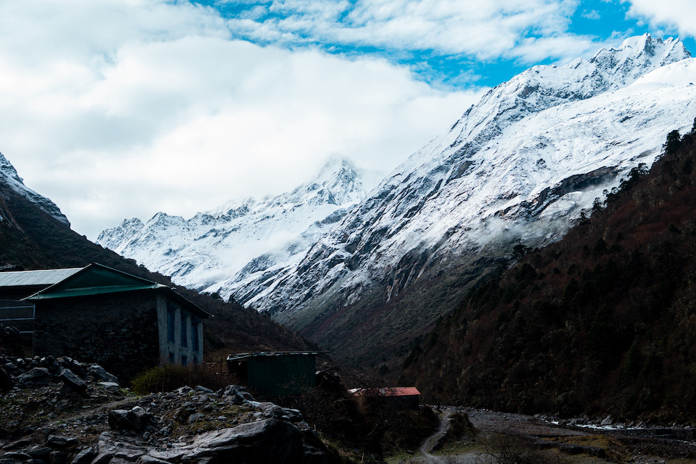
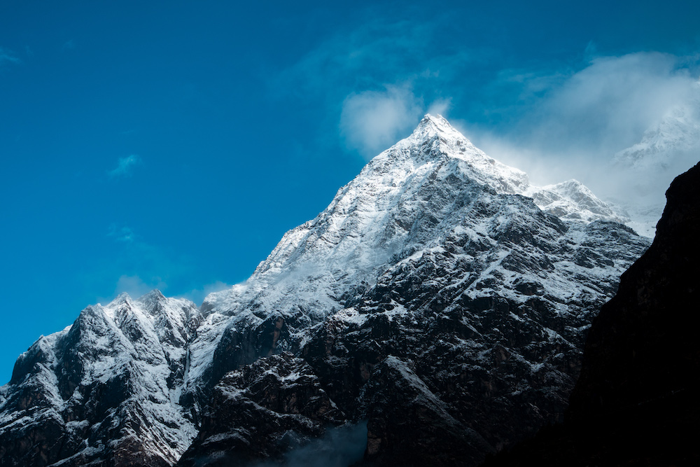
The majestic Chekigo Mountain revealed its white body and smiled. Beding village expanded with abundant sunlight and the white snow illuminated it. With the touch of dew to the ground falling from the trees, everything starts to wakeup. The serene atmosphere of the rugged terrain and the Himalayas filled the faces of the villagers with a blossoming smile. The Rolwaling River continuously flowed with its melodious sound in unison with the surroundings. Clouds revolved around the peaks of the Himalayas, as if trying to touch the summit. In the morning, we turned to the left to witness the birth of a new day. We were captivated by the divine play of nature.
From Beding, trekkers can reach Everest Base Camp via the Tashi Lapcha Pass, making it possible to reach up to the Everest region. Under the Great Himalaya Trail, which is considered the largest trekking route in Nepal, the significance of this trail is immense. With effective promotion, the future holds the potential for an even greater influx of tourists to this area. By promoting its natural and religious aspects, not limited to Beding alone, the entire country can benefit from the increased flow of visitors.
The road to Naa Village is rough to some extent. With a tired and aching body for three consecutive days, there was some relief on that day.
To reach Tsho Rolpa, you just have to walk beside Rolwaling river from Chet Chet. This Rolwaling valley, originating from Chho Rolpa gradually merges with the Tamakoshi River at Chet Chet. Known as the second richest country in terms of water resources, Nepal has numerous rivers flowing from the Himalayas to the Terai region. Valleys like Rolwaling not only provide water for drinking but also facilitate irrigation for farmers and generate energy for lighting homes throughout the country. The valley is not just limited to the land but encompasses us all. We, Nepalis, are the children of these rivers and our lives revolve around them.
In the morning, the weather turned fierce again, and it started raining. We thought of a trip without the rainfall but it wasn’t possible. Due to the foggy weather, we couldn’t see the Himalayas around. After crossing the hills, these mountains were supposed to be right there in our eyes, but we couldn’t catch a glimpse of them.
As we ascended, the air became thinner, and even the wind started to weaken. The lack of oxygen was making us more tired than ever before. We were at an altitude of 4183 meters, higher than the elevation of 3709 meters in Beding, It was expected to be a little uncomfortable.
During such times, it is necessary to stop the journey at intervals. When there is a lack of oxygen in the body, ascending to higher altitudes further puts life at risk. Therefore, it is advisable to rest periodically and only proceed forward after allowing the body to acclimatize.
Due to the bad weather, we couldn’t see much beyond the trail. We were aware that we were heading towards Naa Village, but we had no experience of how the geography changes along the path. As we reached higher, we encountered steep slopes in the terrain. Seeing those slopes, it became evident that yaks play the biggest role in the development of Nepal’s Himalayan region. They are instrumental in carrying heavy loads and building roads, and they provide transportation and sustenance in these difficult terrains.
The trail was relatively easy. There was no immediate need to climb steeply like in the past few days due to higher altitude. As the altitude increased, it became slightly uncomfortable for the body, but we continued to progress further. The deep and untouched parts of the Himalayas ahead seemed distant and mysterious. How strange it seems to people when they see the terrain up to the mountains and in the plains.

We also felt the same, while heading in that direction to Naa Village.
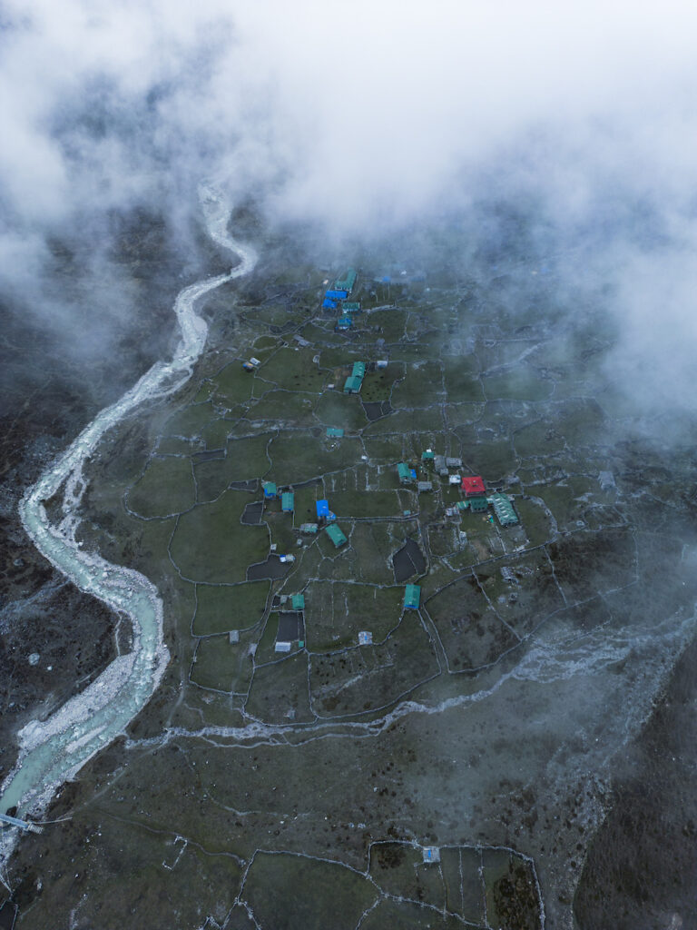
Naa Village is the last village on the Tsho Rolpa trekking. Situated at an altitude of 4,183 meters above sea level, this village has around 50-60 houses, predominantly inhabited by the Sherpa community. With two beautiful lakes, Tsho Rolpa and Dudh Kunda, which hold religious and natural significance, this place attracts a considerable number of pilgrims and tourists, especially during the monsoon season.
People can see Tabuche, Na Go, Yalungri and Kimago Himalayas from here when the weather is clear.
There is an interesting story in Naa Village. It is said that a guru declared it as a violence-free zone against animals. As a result, all forms of animal hunting and killing are prohibited here. Even the yaks in this place, when they grow old, have the privilege of natural death. This belief holds that not only humans but also animals have the right to live with dignity, and Naa Village, located inside the trekking route of Tsho Rolpa, upholds this principle.
Naa Village is not suitable for living during the winter months as it gets extremely cold. Due to this reason, people migrate towards lower regions. It was discovered through conversations with the locals that hotels in the area operate in a similar manner.
After sunset, the darkness engulfed Naa Village, and the drone that had flown up captured some clear visuals of the village. The next view showcased the deep valleys between the towering Himalayas and the open Rolwaling valley. The geography of Naa Village was even more breathtaking than any imaginary scenery.
Two beautiful destinations can be reached from Naa Village. The first destination is Dudh Kunda, which takes a 3-hour trek on foot, and the second destination is Tsho Rolpa Lake, which takes a trek of around 2 and a half hours.
After continuous walking for a few days, we were about to reach our destination. The eagerness to see the biggest glacial lake in Nepal had energized us. Along with fatigue, we kept following the same trail of Rolwaling Valley. Even on that day, we remained captivated by its beauty. Now, after a few more hours of travel, we will finally arrive at Tsho Rolpa Lake. That feeling was making us happy. These thoughts revolved in our minds throughout the journey. The impatience that is born in the heart while writing the last page of the answer book in the examination, we had the same impatience in our heart when we stepped from the village towards Tsho Rolpa.
After a short walk, we reached Sangmading which is at 4190 above sea level. From there, the road to Yelung will split. Leaving the Yelung road behind, the mountains appeared closer as we proceeded to the bridge made of tree trunks. You can also take a look at the beauty of the mountains.
We continued to walk furiously. When we saw the Tsho Rolpa lake above from the drone, there was no excitement in that area, we were happy even if it was a little.
While walking along the road, we came across a signboard. It mentioned that the construction work of Lapcha Pass Trail under the Ministry of Tourism of the Government of Nepal had started in 2079/06/05. Due to such initiatives undertaken by the government, various trails in the country have become easily accessible. Creating staircases in previously inaccessible areas and placing sign boards to organize the trails have contributed to the development and safety of the tourism sector in the region. Moreover, the government has invested 2 crores 50 lakhs Nepali Rupees to provide electricity to the Tsho Rolpa trail, which has made a significant contribution to the tourism development of this area.

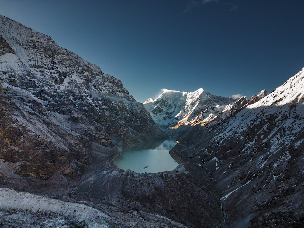
Tsho Rolpa Lake within Gaurishankar rural municipality of Dolakha district is the largest glacial lake in Nepal.
Tsho Rolpa Lake is the largest Glacial Lake in Nepal. The lake, which is said to have originated about 50 years ago, is at a height of about 4580 meters above sea level. We have been hearing repeatedly in the news about the danger of the Tsho Rolpa glacier exploding. In 1991, the explosion of Chubung glacier near Tsho Rolpa caused damage to Beding village. The danger posed by the explosion of Chho Rolpa glacier will be multiple times greater than that of Chubung glacier..
Tsho Rolpa poses a threat to the risk of life. Creating a focal point in the surrounding area if there’s an earthquake there is the possibility of a glacial explosion. Various efforts have been made to mitigate this danger, but they have been insufficient to date. In 1963, the lake covered an area of 0.23 square kilometers, but by 1996, it had expanded to 1.68 square kilometers. The expansion of the lake’s surface area has created risks for settlements located downstream.
If there is something to forget about the danger, then Tsho Rolpa itself is a paradise. After witnessing the beauty of Tsho Rolpa Lake, located in the lap of Himalayan giants like Gaurishankar, Taboche, Nago, Yalungri, and Kimago, one cannot help but be amazed. The water of the lake, surrounded by clouds clinging to the Himalayan peaks, serene atmosphere, and gentle winds, carries a kind of tranquility that cannot be perceived through the fast pace of life. The beauty of the whole world is the expression dug in that one place.
After a 7-day long journey, reaching Tsho Rolpa felt like winning a great battle. The continuous steep trails for 5 days, the rainfall, the monsoon season, the veil of fatigue that overshadowed the desire to behold the Himalayas we faced it all. Overcoming the height that took our breath away and the exhaustion of the body, we finally reached our destination. No matter how challenging it was, the efforts became meaningful, and we succeeded in bringing Tsho Rolpa within your reach.
We express our heartfelt gratitude to all the sponsors who supported us throughout the journey, our dear porter Shankar Tamang, and everyone who contributed to the success of the expedition. Tsho Rolpa is a place that every Nepali should visit at least once in their lifetime. Being near this massive glacier not only brings tranquility but also helps us become more familiar with many Nepali traditions. Nepal8thWonder Team embarked on a 7-day journey to show you a glimpse of the beauty of Tsho Rolpa. Take your time to appreciate it and immerse yourself fully in the journey. We will meet again in another episode. Keep watching, keep exploring.
Comments are closed.