


Life’s impermanence comes to our attention when we reach a height where even breathing becomes difficult in the usual manner. This journey marks the understanding of impermanence. It is a journey that takes us close to the towering snow-capped peaks and vast ice formations near the highest summit of the world, Sagarmatha. It is a journey that accepts the challenges of the difficult Himalayan life experience, moving forward despite the hardships. It is a journey that precedes those footsteps that have touched and conquered each of those massive peaks, leaving traces on the glorified history. Before this journey, we had not ventured into the upper part of the Solu-Khumbu region. The main reason for tourists coming to Nepal is the proximity to these Himalayas, and this is our first attempt to reach the city of Sagarmatha itself, where even those who do not physically reach the summits of these massive mountains still aim to get as close as possible. This time on this special series of Nepal Eighth Wonder, our journey starts from Lukla, situated at 2860 metres, up to Kala Patthar with an altitude of 5644 meters.
In the Tribhuvan International Airport, we were all geared up for a grand journey. Along with Lukla, Kala Patthar was a profound experience for many of us, marking the first encounter with such a unique aspect of life. Grateful for the opportunity presented to us, we extend our thanks to the Kala Patthar Whiskey.
This time, we embarked on a journey from Kathmandu directly to Lukla with Summit Air. Despite the considerable distance between Kathmandu and Lukla by air, people faced challenges due to unpredictable weather conditions, causing disruptions during flight times. In an effort to cope with the situation, we spent some time in the airport lounge with fellow travelers, and eventually, the moment to fly to Lukla arrived.
This was our second flight with Summit Air. Summit Air has been contributing significantly to connect tourists with the Himalayas for several years. Heading to Lukla, the gateway to the Everest region, we were filled with enthusiasm, although a hint of apprehension lingered in some corners of our minds. Nevertheless, flying with Summit Air, we confidently embraced the journey, conquering all the fears encountered.
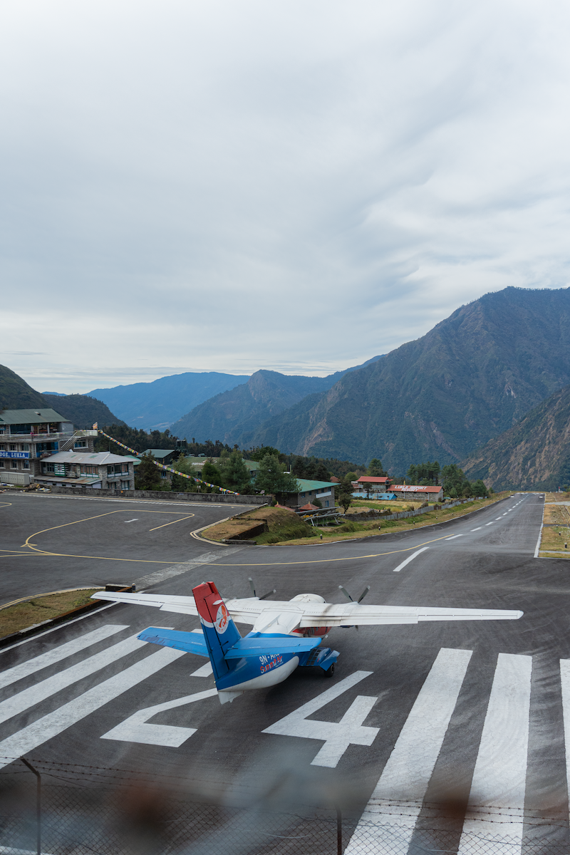
It is possible to reach Lukla by air within a span of approximately 30 to 45 minutes. Due to its geographical layout, Lukla Airport is considered risky. Consequently, having a road section as an alternative to reach Lukla has also been considered. However, the experience of flying amidst the Himalayas in a small aircraft like this was truly exhilarating. Surrounded by clear weather and floating clouds, we made a smooth descent into Lukla Airport.
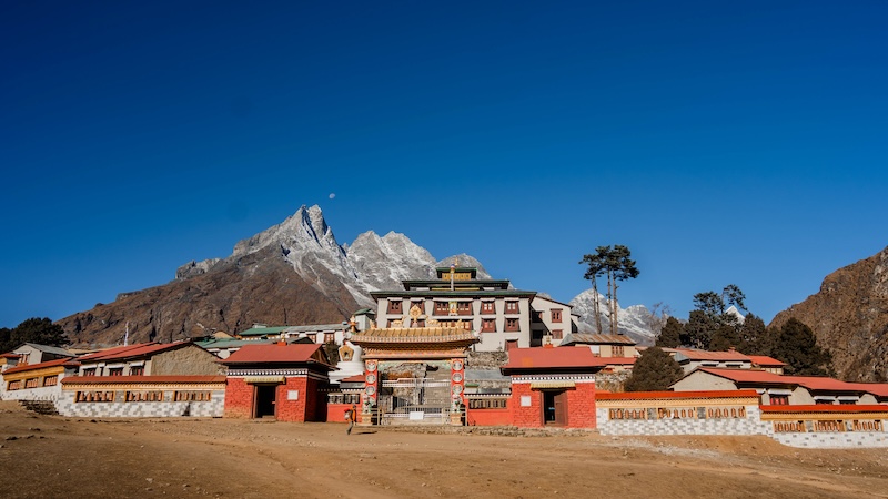
Lukla Airport was constructed in 1964. The initiative to build this airport was led by Sir Edmund Hillary, the first person to successfully summit Mount Everest in 1953. In honour of his historic ascent, it has been named Tenzing Hillary Airport. As we descended into Lukla, we could see the majestic Nupla Himal and the towering Kusum Khanguru Himal standing tall in the vicinity.
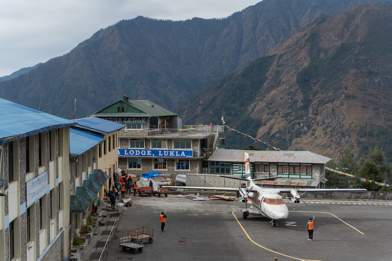
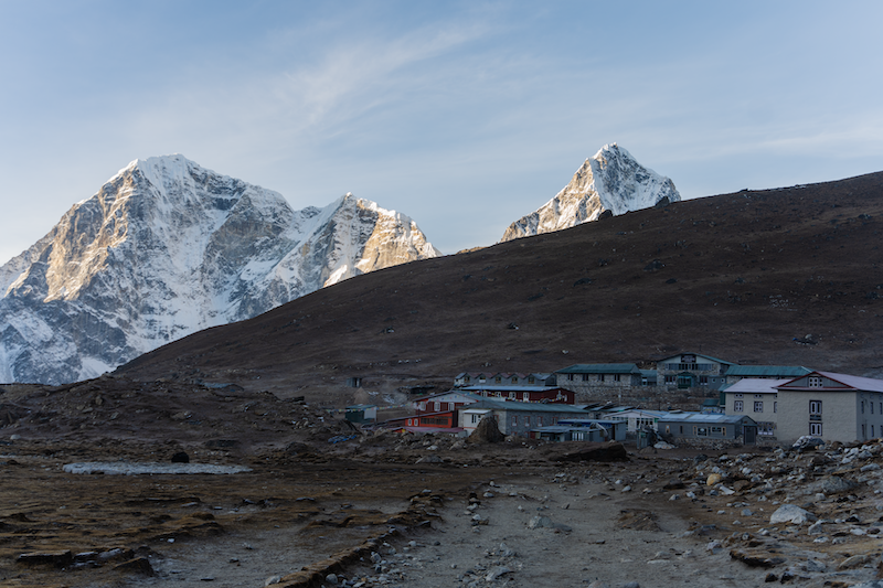
After enjoying our meal at Mira Lodge, we spent time immersing ourselves in the vibrant atmosphere of Lukla. The place is rich with the stories of mountaineers who embark on the challenging journey to conquer the world’s highest peak, Mount Everest. The footsteps of these climbers have left an indelible mark, symbolized by the prayer flags fluttering in the wind and the newfound dimensions of courage standing tall. This influence is evident not only in the landscape but also in the day-to-day lives of the locals. Situated at an altitude of 2,846 meters above sea level, Lukla holds the distinction of being the gateway to the world’s highest peak. The hustle and bustle of Lukla were truly captivating, with its hotels, homestays, cafes, and sublime views of Buddhist culture. Constantly surrounded by such picturesque scenes, Lukla was exactly the same as what we saw in photographs.
After getting lost in the enchanting ambiance of Lukla’s rustic surroundings, our official journey to Kala Patthar commenced. Creating our first steps towards Phakding on the initial day. The quaint homes built on the mountain’s slope welcomed us with their unique charm. There is a continuous influx and departure of tourists. Even during the peak trekking season, Lukla served as the starting point for daily hundreds of mountaineers heading towards the Everest Base Camp. Witnessing climbers from various countries, each with their own culture and language, converging in this natural wonderland was a beautiful sight in itself.
Every village and settlement along the path leading to Everest Base Camp, and the people residing there, are affected by the presence of Sagarmatha. Many locals are directly involved in tourism or mountaineering, either as guides, porters, or in various support roles. In the fiscal year 2022/23 alone, this region welcomed approximately 57,790 tourists.
If we talk about attracting attention, the region within Solukhumbu District has indeed succeeded in becoming one of the most captivating destinations globally. The outcome is evident in the high quality and standards of the pathways we observed along our journey.
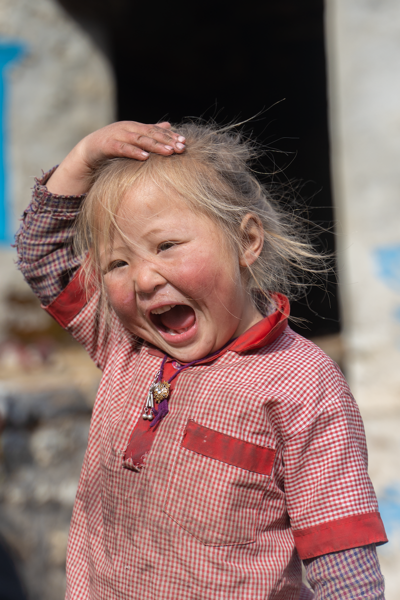
Along the way, spending some time with the little children added an extra dose of energy to our journey. As if the mountain was there guardian and these little kids were blooming in it’s vicinity enduring all the hardships.
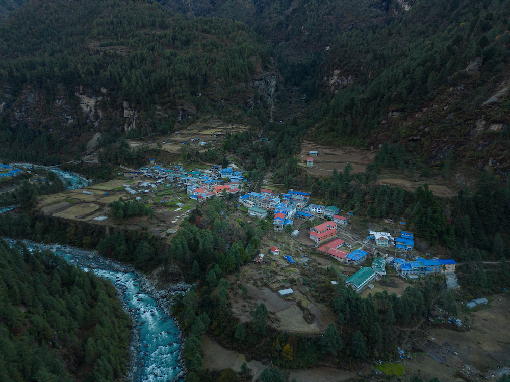
As we traveled from Lukla Airport to Cheplung, Cheplung to Thado Koshi, and finally arrived at Phakding, the Himalayas, weather, and the people we encountered along the way filled our hearts with delight. Ultimately, on the first day of the journey to Kala Patthar, we reached up to Phakding.
In the Sherpa language, Phakding translates to “the place where the deity resides,” suggesting a divine presence in this locale. Phakding is considered no less than a heavenly abode. It is situated near the confluence of Dudh Koshi, an incessant flowing river. Nupla Himal stands majestically in close proximity. Positioned at an altitude of around 2,650 meters above sea level, Phakding serves as the familiar stay for the first day of the Everest Base Camp trek. With a limited number of houses, Phakding primarily accommodates individuals involved in tourism, hotel businesses, as well as those engaged in agriculture.
On the second day, with the hope of gathering new energy and experiences, we bid farewell to the Shangri-La Hotel and resumed our journey on the trail. We express our gratitude to Nawang Dai for providing us with warm hospitality.
The weather was clear, revealing the majestic Himalayas in all their glory. The village of Phakding was nestled in the lap of the Himalayas, showcasing its mystical charm. Every scene we encountered on our journey was enchanting. The living, language, and culture in Phakding were unique, yet we found a sense of familiarity. Despite the differences, we could sense closeness.
The change in the atmosphere was slowly being felt. The gentle flow of the Dudh Koshi river and the continuous murmur of its clear waters added a soothing melody to the environment. It was an enchanting experience that made us forget the fatigue of the trek along the Everest trail.
Along this trail, there are various facilities, whether it be through air transport or the expansion of trails to accommodate yaks and porters. Due to this, we keep on encountering yaks and porters carrying supplies.
Approximately 3 kilometres south of Phakding lies the village of Chomo. In Chomo, we found solace for our hunger and fatigue. Much like other villages in the vicinity, Chomo embraced the essence of the Buddhist culture, and daily life reflected the principles of Buddhism. Situated at an elevation of 2,835 metres above sea level, Manjo, which is an alternative place to stay other than Phakding.
After Manjo, we officially entered the Sagarmatha National Park. Covering an area of approximately 1,148 square kilometres, this national park earned its place on the UNESCO World Heritage List in 1979.
The suspension bridge added an extra dose of enthusiasm as we approached Larcha Dobhan. The sound of the Dudh Koshi river, flowing beneath the bridge constructed across the steep mountain gorge, left us mesmerised. We were now in the buffer zone of Sagarmatha National Park, where the lush vegetation and diverse flora added to the enchantment of the surroundings. Even in this remote wilderness, signs of human presence were evident, harmoniously blending with the natural beauty.
As we reached Namche, the day had started to fade. The day’s journey, with its constant ups and downs, was exhausting, but the novel scenery of Namche infused us with additional energy. In the heavy settlement of Namche Bazaar, we witnessed a blend of tradition and modernity. The unique architecture of houses, stupas, and the proximity to the Himalayas adorned Namche with an aesthetic charm. The enchanting view was truly otherworldly.
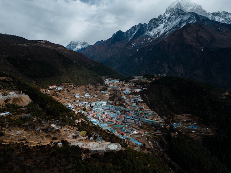
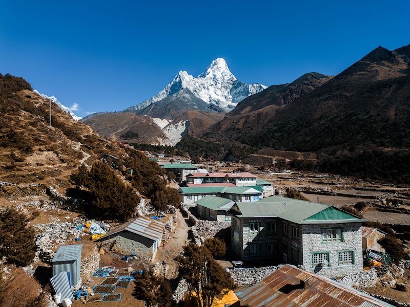
The panoramic views of Himalayan peaks like Kongde, Taboche, Nupse, Lhotse, Shrestha, Amadablam, Thamserku, and others had made the morning arrival enchanting. Being able to see the Himalayas up close in the morning left us in awe. You can also see Khumbila Himal from Namche, which is worshipped as the deity of Khumbu. Located at an altitude of 3,460 meters above sea level in Namche Bazaar, the Sherpas’ hospitality is evident. Due to the Himalayan backdrop, the scenes, cultural perspectives, and other aspects visible from there have left a remarkable impression on the trekkers. Namche, under the Himalayan shelter, showcased the influence of the Sherpa community and their culture.
The acclimatization process in Namche Bazaar is crucial for those attempting to climb Sagarmatha Base Camp or undertake an Everest expedition. This means gradually adapting to the changes in physical condition that occur after ascending significantly from sea level. Acclimatization becomes necessary to cope with such changes without adverse effects. Therefore, our plan was to acclimatize by reaching Namche View Point on that day, with the ultimate goal of reaching Sagarmatha. However, due to weather conditions, that plan couldn’t materialize. Another plan was in place, which was successfully executed.
The third day of the journey was spent at Kala Patthar Whisky Shoot. We were heading towards a new height, where each of us experienced some profound impact in our lives. It marked a new chapter in the book of life, adding new dimensions and perspectives. We were truly grateful to Kala Patthar Whisky for this beautiful journey.
As the evening shadows played on the slopes of the Himalayas, we descended to Namche Bazaar. The easygoing hustle and bustle of people at this altitude from the sea level was a magical sight in itself. Namche Bazaar, with its vibrant colors, had woven a unique charm for newcomers like us. The energy of the mountaineers, the stories in every step, and the history embedded in the alleys made Namche a beautiful spectacle, especially during the night.
Namche had an extra charm during the night. While the rest of the world slept, Namche neither sleeps nor lets the Himalayan peaks overlook sleep. The well-equipped facilities, such as hotels, bars, and cafes, catered to the tourists. We, too, immersed ourselves in the enjoyable ambiance with our team. At the end of the third day of the journey, we relished some delicious food at the Hungry Yak Restaurant.
At times, Namche was a place for those dwelling in the Himalayan region to buy commodities. In history it used to serve as a hub for trading yaks and dairy products. After Sir Edmund Hillary and Tenzing Norgay Sherpa conquered the world’s highest peak in 1953, global attention shifted towards Nepal, and Namche entered the spotlight. This brought discussions and eventually led to the transformation of Namche. Leaving Namche behind, we embarked on the journey again after a day of rest.
We express our gratitude to Hemant dai for providing quality accommodation at Hotel Snowland. After we gave him the token of our appreciation, our journey resumed now with a farewell to the beautiful environment of Namche, heading towards Tengboche.
The Solu-Khumbu region is adorned with more than a dozen monasteries, each contributing to its cultural richness. The captivating structures and the serene atmosphere inspire travelers. However, more than just the visual appeal, witnessing the Sherpa community’s genuine warmth towards adventurers, not just as tourists but as part of their extended family, left an indelible mark on us. The Sherpa community, with their humility and love, has played a significant role in spreading Nepal’s name globally through their association with the Himalayan peaks. Experiencing the Sherpa way of life and culture was indeed a cherished and favorite part of our journey.
After reaching Kyangjuma, we decided to take a break and prepare a meal ourselves. In front of us, the majestic Himalayan collage unfolded, with its vast and breathtaking beauty. The weather’s crispness added a natural charm. As the intensity of the sunlight increased, the crispness also heightened in proportion. Resting in the serene atmosphere around iconic Himalayan peaks like Kongde, Thamserku, Ama Dablam, and Lhotse, we rejuvenated ourselves for the upcoming journey towards Phungi Thanga.
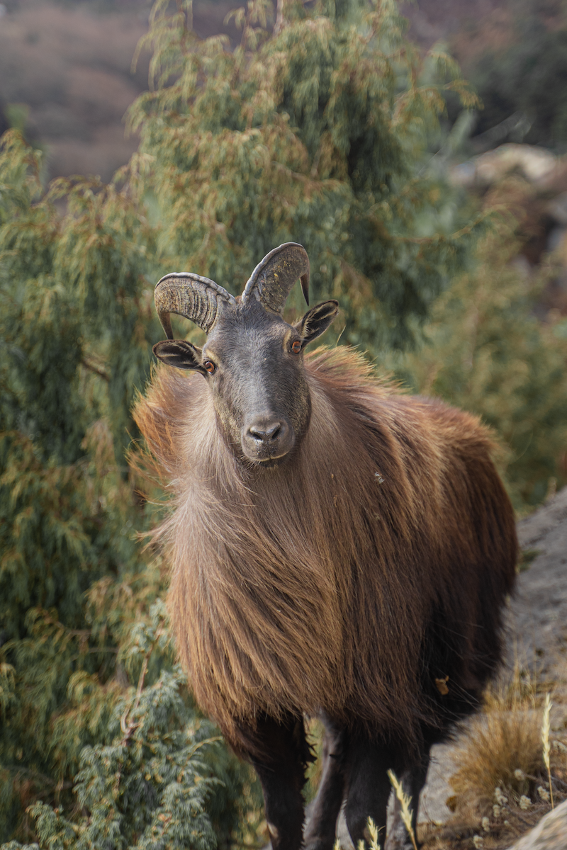
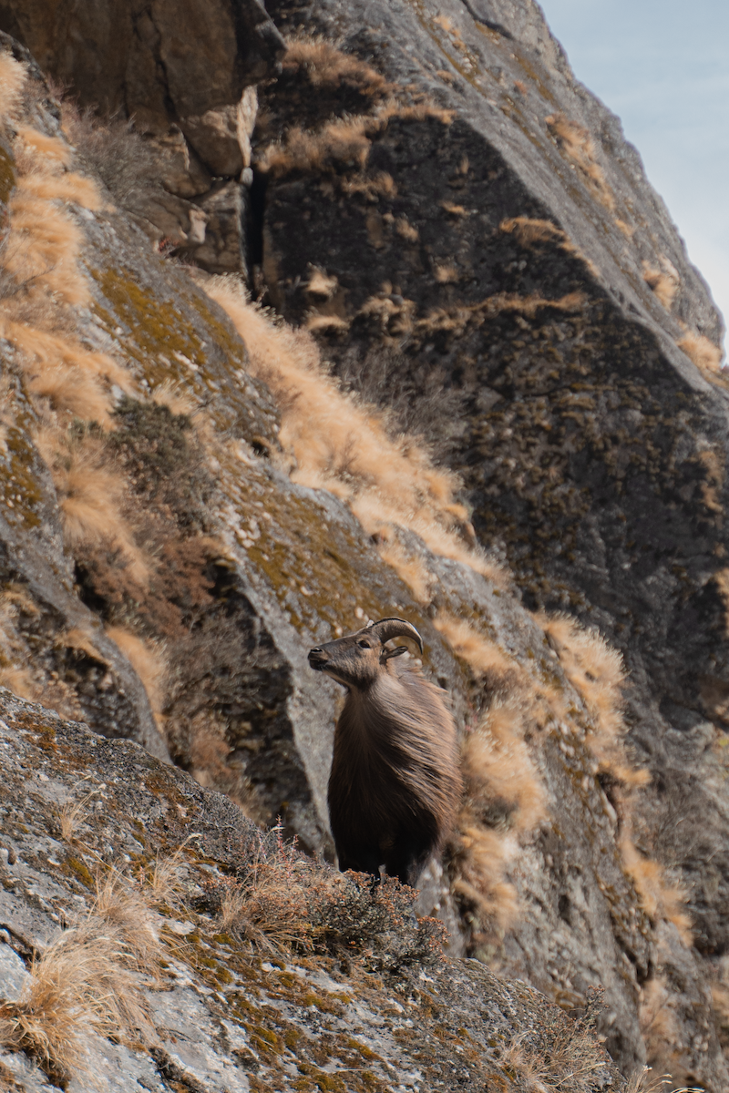
Gokyo Lake is also a familiar destination for seasoned travelers. We deviated from the path to Kala Patthar. Along the trail, we reached various settlements, and the trekker in us felt accomplished. The biodiversity along the route was abundant, and we even encountered yaks grazing. As we walked along the trail, we spotted wildlife such as Himalayan Tahr. Preservation of such wildlife seemed very important.
The enchanting Himalayan landscape along the trail made the journey thrilling. The Himalayan way of life, shaped by the towering mountains, brought a unique perspective to our experience. We witnessed the traditional agriculture and the resilient lifestyle of the people thriving amid the challenges of fast-paced tourism development.
As we continued on the challenging trail, we encountered villages nestled along the route. Crossing forests, jungles, rivers, and steep slopes, we finally reached Phungi Thanga.
Situated at an altitude of around 3,460 meters above sea level, Phungi Thanga, with its abundant dairy farms, served as our resting place during the trek. This small village, with limited dwellings, aimed to provide facilities for those embarking on the trek. After having a meal in Phungi Thanga, we continued our journey along the trail. As we ascended, the wind grew thinner, and the dense forest gradually gave way to open landscapes.
As we started heading towards our destination, Tengboche, the sun was casting long shadows as it gradually descended in the western sky. Experiencing the sunset in the lap of the Himalayas is always a cherished moment. With the evening approaching, we hastened our pace towards the hotel, eager to find warmth and comfort.
Tengboche, adorned in the panoramic embrace of the Himalayas, presented itself with the majestic forms of Lhotse, Ama Dablam, Sagarmatha, Thamserku, and other towering peaks. Located at an altitude of 3,867 meters above sea level, this place holds immense religious and historical significance. The Tengboche Monastery, a prominent Buddhist monastery, adds to the spiritual aura of the region. Additionally, Tengboche is renowned as the birthplace of Tenzing Norgay Sherpa, the famous mountaineer. Due to its elevation, the climate here is characterized by tundra conditions, with the minimum temperature reaching around -10 degrees Celsius in the cold season and a maximum of around 14 degrees Celsius in the warmer months.
The Tengboche Monastery is a significant monastery in the Khumbu region. It was built in 1923 and has been renovated several times since then, notably after the earthquake in 1934 and the subsequent damages in 1989. The construction of the monastery was funded by the local community, and materials were transported from places like Lasaa. The stones around Tengboche on which “Om Mani Padme Hum” is inscribed, added spiritual beauty to the place. Every year a day marking the establishment of the Buddhist religion, and devotees gather at the monastery to offer prayers. Also, mountaineers pray before ascending in their journey.
Our accommodation in Tashi Delek was well-equipped, providing excellent hospitality. We are grateful to the hosts for their warm reception. After having breakfast in the morning, we set out on our journey again. As we descended through dense forests, the weather remained cold even when the sky was clear. Everest, Sagarmatha, and Chomolungma whatever be the name may only represent mountains for some, but for every individual here, they hold a unique significance. Throughout this journey, we had the opportunity to meet people from different walks of life, all connected by the Sagarmatha. It was an experience of courage and sensation that we hadn’t encountered before. Each location had its own stupas, gumbas, and stone gates, welcoming us to Pangboche.
Pangboche is situated approximately 3 kilometers within the Khumjung Rural Municipality from Tengboche. The trail leading from Ama Dablam’s base camp, visible even from Lukla, separates from Pangboche. Ama Dablam stands at an elevation of 6,812 meters above sea level and is renowned for its beautiful snow-capped peak. The name “Ama Dablam” translates to “Mother’s Necklace,” representing the unique shape of the mountain. Despite being closer to the trail than other peaks, Ama Dablam captivates with its stunning appearance. Here, you can also find gumbas, chaitis, and stupas. While our final destination wasn’t Ama Dablam, we continued past Pangboche towards Kalapatthar.
After having our meal in Somare, we lost ourselves in the breathtaking views of the Himalayas. No matter how much we looked, it never seemed enough, and the beauty was mesmerizing. The serene, majestic, and immovable Himalayan panorama left us in awe. After soaking in the views, we continued our journey ahead. Along the trail, we encountered a yak grazing peacefully. The vegetation was thinning out, and the atmosphere was incredibly calm!
Throughout the day, we were moving at our own pace. In the memories of the journey, it’s hard to say whether it was a smooth or challenging side of the expedition. The outcome of such a journey is uncertain. What is clear is that the journey was vast. Those memories were enormous. Comparing them is impossible. We were grateful towards Kala Patthar for this immense opportunity.
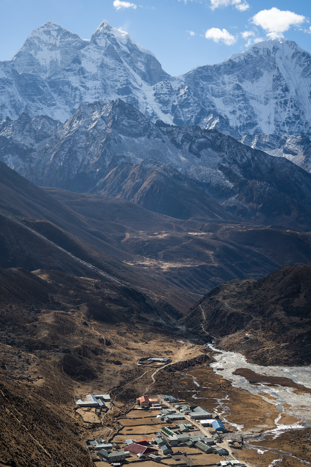
We started from Tengboche early in the morning and reached Dingboche with a sense of accomplishment. As we arrived in the peaceful lap of Dingboche, our fifth day was coming to an end. Now, what kind of gift has nature prepared for us? We were eager to find out.
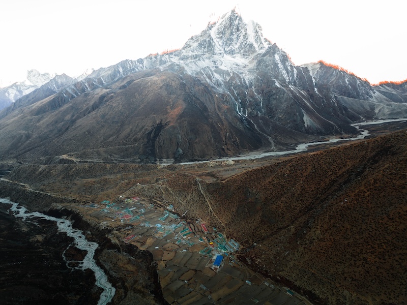
Dingboche, situated at an altitude of 4,410 meters above sea level, marked the beginning of our sixth day of the trek. Dingboche welcomed us with expansive views of majestic Himalayan peaks such as Taboche, Cholatse, Cho Yu, Lobuche, Nuptse, Island Peak, Ama Dablam, and many others. Dingboche, surrounded by this vast panorama of Himalayan giants, offered us a day to stay for acclimatization.
After reaching such high altitudes from sea level, experiencing difficulty in breathing was a natural occurrence. However, the majestic beauty of nature compelled us to stare at it, and the desire to explore the sublime landscapes made us forget about the challenges. The spiritual aroma permeating the land, intensified by the flowing river formed by melting snow, added an extra layer of tranquility. We found ourselves immersed in the atmosphere.
Furthermore, the deep isolation of the region made it challenging to harness energy from conventional sources. Witnessing the successful implementation of solar energy as a sustainable energy source added another dimension to the landscape. It also made us realize the difficulties associated with obtaining such facilities in such remote areas.
After completing the journey, we all felt like one big family. With each ascent and descent, we accumulated numerous experiences. There were stories and tales to share. The hospitality of Peaceful Lodge’s caretaker, resembling that of a family member, made that moment truly enchanting. The various facets of our journey, enriched by individuals like Sere Dai, Pradip Dai, Suman Khatri Dai, and Jayaraj Khadka Dai, felt like creating an inseparable bond that continued to uplift us from Lukla and beyond. Spending evenings like this with constant travel has proven to be remarkably impactful. As the Himalayan peaks turned golden in the twilight hues, we bid farewell to the colorful ranges, concluding another chapter in Dingboche.
Being surrounded by the Himalayas as we lay down to rest and waking up in the morning to witness the Himalayas was such a plight. Dingboche, nestled beside the tranquil Himalayas, felt like a mystical settlement created in the mind of a fiction designer. After enjoying our breakfast, we thanked the caretaker of Peaceful Lodge by providing her with the Kala Patthar Whisky. We embarked on one of the most challenging treks after Dingboche. As Lobuche became our next destination. The higher altitude brought crisp air, and the surroundings were pristine. The vast meadow surrounding us captured our attention as we marveled at the beauty of the open field.
Generally, as we ascend above the sea level, the concentration of oxygen in the air decreases. Due to this, many of us experience symptoms like shortness of breath, body fatigue, and headaches. These symptoms were evident among us as we hiked through higher altitudes. However, the fear of potential complications and the question of what to do if the situation worsened kept us cautious. On one side, such fears haunted us, while on the other, the breathtaking views of the Himalayas captivated our minds. Balancing our journey with care, we took the time to acclimatize, recognizing our body’s limitations at each stop. Despite the initial concerns, the weather favored us, providing us with an opportunity to fully enjoy the majestic Himalayan landscapes.
Sun was glimmering just for the shake of the day. Upon reaching such altitudes, imagining the harshness of the cold in the middle of winter was beyond our comprehension. In every settlement, we encountered a landscape of rocks and stone houses. We were constantly walking through the riffs created by glaciers and we could see nothing but snow, Himalayas, and the sky. After crossing that opening, we reached a small settlement called Thukla.
After continuously ascending from Dingboche, we reached Thukla and found a place to rest. Since there were no other settlements along the trail, Thukla provided facilities for trekkers and mountaineers to eat and stay in hotels. After having our meals and taking a short break in Thukla, it was time to resume our journey. We carefully considered the path leading towards Lobuche as our destination.
There aren’t many options for transporting goods to a place like Sagarmatha. You either have to carry the supplies on your back from below, hire a helicopter service, or explore other alternatives that we hadn’t considered.
Many people dream of climbing the Himalayas atleast once in their lifetime. Even if that dream is not fulfilled, getting close to the Himalayas at some point in life, absorbing that environment, and incorporating the lessons learned from that journey into life seems very fascinating. However, life itself is transient, and its fleeting nature cannot be altered by anyone. After reaching the Thukla Pass, we observed a serene atmosphere of sorrow. There was the memorial of those mountaineers who have climbed Sagarmatha and couldn’t return safely. We prayed for their soul to rest in peace.
With a heavy heart and burdened feet, we moved forward, without any alternative before us. At times, we pondered how life will cost us so dearly. Those who proclaim that breathing is easy might also discover in this journey that everyone’s life is abstract. Living, too, is abstract. We learned on this journey that while it may seem easy for us, is it really easy for everyone?
Like a string of pearls, the Himalayan mountain range stretched ahead of us. Though our path initially led us directly towards Lobuche, Chola Pass was a familiar destination in the distance. After ascending from Kalapatthar or the Everest Base Camp, trekkers often follow the same route towards Gokyo Lake, passing through the rocky terrain of Chola Pass sculpted by the Khumbu Glacier. While we, heading towards Lobuche, followed the trail marked by the rock formations crafted by the Khumbu Glacier.
We reached Lobuche before the day turned dark. Our journey had proven to be one of the most challenging ascents. Despite the fatigue, we found solace in the camaraderie of fellow trekkers. Taking short breaks, we shared our experiences with other travelers, gaining a sense of relief and comfort from their stories as well.
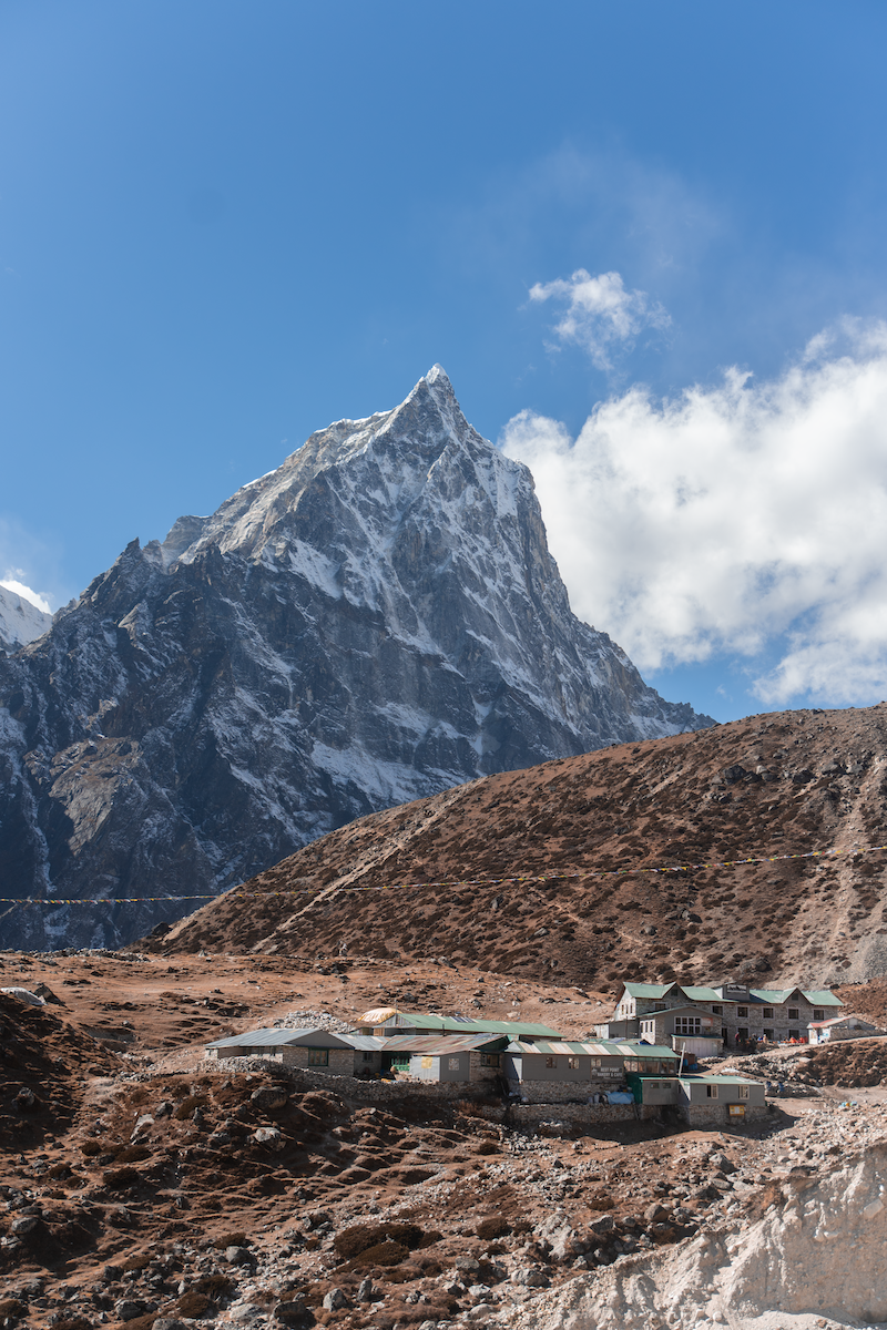
We found ourselves at an altitude of 5030 meters, well above the sea level. Before our eyes stretched the magnificent views of Pumori, Lingtrung, Khumbuche, and Nupse Himal. The atmosphere was enchanting as the sun’s radiant rays illuminated these majestic peaks. Compared to other places, Lobuche felt significantly colder. The few scattered lodges and teahouses in Lobuche serve as a suitable stop for mountaineers and trekkers to spend a night.
No matter how challenging and tough the journey gets, there’s always something that keeps pushing us forward with constant determination. This resilience can be a source of inspiration for the audience. It might create a bond of love among the viewers. It’s the love emanating from camaraderie or the love expressed for the Himalayas that emerges from within. Whatever it may be, with such determination, we move ahead. Before setting off, we expressed our gratitude to the manager of Mother Earth Hotel by providing him with a travel pack of Kala Patthar Whisky.
The steep cliffs posed a challenge, but when we conquered those challenges and ascended the steep incline, we were welcomed by the grandeur of Pumori Himal standing tall and majestic, showcasing its enhanced beauty.
We hold so much affection for the Himalayas because its majestic views, like other natural scenes, captivate our hearts. When we look back, it feels like we have arrived at a place that has separated itself from human reach. There stand the towering peaks, each with its unique charm. The challenging journey through these breathtaking views justified itself. We found ourselves in moments where we lost to the scenery, and in those moments, we discovered an opportunity to recognize our own existence.
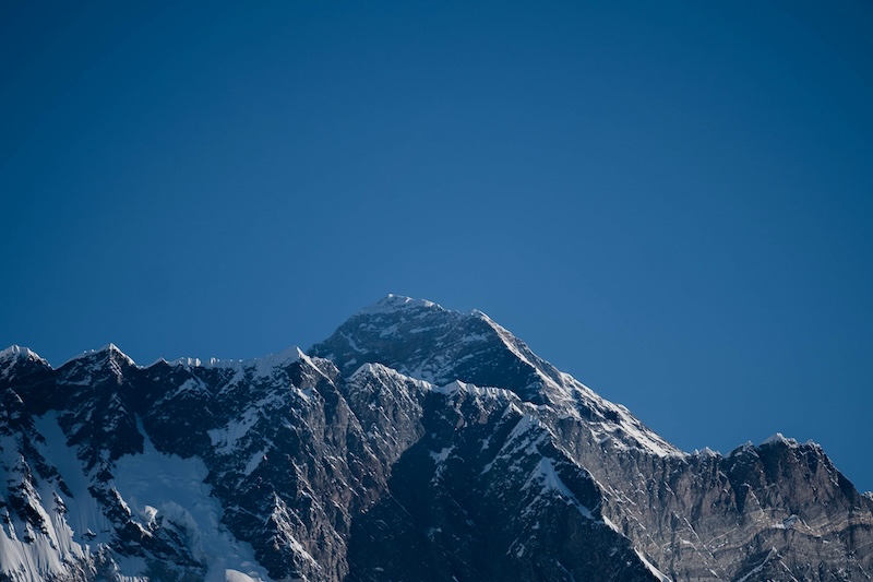
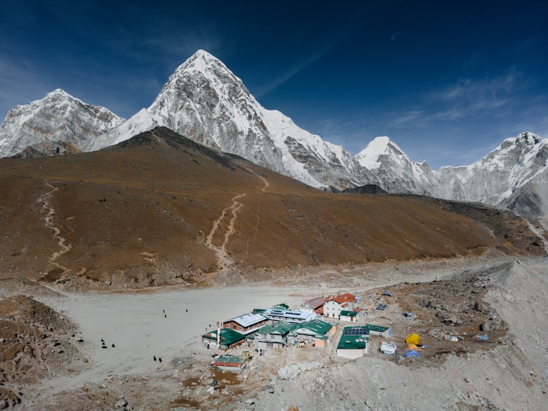
The Himalayas loomed large in the distance from the very beginning. As we approached the Khumbu Glacier, the imposing peaks and unique formations of those mountains appeared like small sculptures crafted by a skilled designer. After reaching Gorakshep, a small settlement, our main destination, Kala Patthar, was not that far. It was from Kala Patthar that we could directly witness the grandeur of Mount Everest, along with Lhotse and other majestic Himalayan peaks.
Gorakshep is the final station before reaching the Everest Base Camp along with the path leading to Kala Patthar. We were amazed to find accommodation and food facilities there as well. After having our meal and taking some rest in Gorakshep, we continued our journey forward. The trail from Gorakshep to Kala Patthar and Everest Base Camp is separated. According to local accounts, Gorakshep was initially considered the base camp for Mount Everest before the establishment of the current Everest Base Camp.
Moving forward from Gorakshep, the journey became truly meaningful from the very first day. The thin air made breathing extremely difficult. We stopped at various places, taking in the emptiness around and preparing ourselves for the challenges ahead. Those moments of uncertainty were defining, where every step felt courageous. We had been eagerly anticipating those moments for a long time.
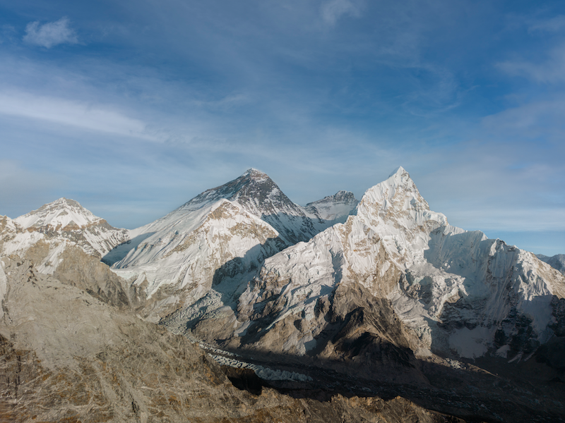
After a brief climb, we reached our main destination, Kala Patthar. It was the first time in our lives that we had come so close to Mount Everest, reaching an altitude that surpassed any previous experiences. The view, the moment, and the entire experience were beyond measurement, something that could not be captured by any device or described by words.
Situated at an altitude of around 5644 meters above sea level, Kala Patthar is considered one of the most suitable places for observing the panoramic view of Mount Everest. Typically, trekkers visit Kala Patthar after reaching the Everest Base Camp. The unique topography of Mount Everest makes it challenging to see its summit clearly from any other vantage point. Weather changes in an instant, affecting the visibility of Mount Everest from Kala Patthar. Therefore, trekkers make their way to Kala Patthar to get a closer and clearer view of the majestic summit of Mount Everest.
The world’s highest peak, which is situated at an elevation of 8848.86 meters above sea level, is recognized as Mount Everest. It is a landmark that has brought global recognition to Nepal. Thousands of tourists come to witness it every year, and Mount Everest, along with its association with Nepalese identity, stands as an emblematic symbol. However, it’s not just about Mount Everest; it was part of the entire Himalayan range. This natural palette that spreads below is not only breathtakingly beautiful but also a small yet distinct Nepal.
Surrounded by Himalayan giants, including Mount Everest at 8848.86 meters, Lhotse at 8516 meters, Pumori at 7161 meters, and peaks above a thousand meters such as Thamserku, Kangtega, Taboche, and Lobuche, we had the opportunity to witness these majestic mountains up close. Grateful for such an experience, we express our thanks to Kala Patthar Whisky for offering us this opportunity.
From Kala Patthar, the sun’s rays painted the summit of Mount Everest in vibrant colors. After sunset, we descended from Kala Patthar and returned to Gorakshep the same day. It was a moment where new experiences had blossomed on the canvas of our lives. We embraced those moments as a celebration, marking them as a festival of life. From Gorakshep, we headed towards Pheriche. Typically, mountaineers and trekkers returning from Everest Base Camp make Pheriche their stop rather than Dingboche. From Pheriche, we descended further and eventually arrived at Namche. After that we went to Lukla. It serves as the final stop for many mountaineers and trekkers before heading back home. It marked the conclusion of our grand Kala Patthar journey. In Lukla, we celebrated the success of this monumental journey with friends.
In this journey that began from Lukla Airport, we have collected many new experiences. From the mesmerizing Ama Dablam to the spiritual mantras inscribed on the stones along the path, and the beauty of the rhododendron forests found in the Himalayan region. During this journey, we had the opportunity to absorb the history from one of Nepal’s oldest stupas. Similarly, while passing through the challenging Thukla Pass, we were awestruck by the fragility of life. Amidst the difficulties of the Himalayan terrain, we found solace in the hospitality of the Sherpa community. We shared our experiences with both foreign and domestic tourists. Confronting every challenge on the path to the world’s highest peak, Sagarmatha, added a new chapter to our lives. All these experiences would not have been possible without Kala Patthar Whisky. Hence, we express our gratitude to Kala Patthar Whisky. Beginning from the initial days, our joy and sorrow have been shared by Sere Dai and Pradip Dai, to whom we are immensely grateful. We are thankful to Suman Khatri Dai and Jayaraj Khadka Dai, whose guidance has always kept our spirits high. A heartfelt thank you to all the hotel operators for their exceptional hospitality throughout the journey. Lastly, we are grateful to our dear audience, whose love and encouragement have been a constant source of inspiration, propelling us to such heights. Wishing you continued affection, we look forward to meeting you in new places, environments, and experiences. Until then, farewell!
Our Kalapatthar’s Itinerary:
Day 1 : Kathmandu – Lukla Airport (2846m) – Phakding (2610m)
Lunch: Mera Lodge, Lukla – 9841128666
Stay: Shangri La Guest House, Phakding – 9851223749 [ NGAWANG DAI ]
Day 2 : Phakding – Chumoa (2830m) – Monjo (2835m) – Top Danda (3140m) – Namche Bazaar (3440m)
Lunch: Chumoa Guest House – 9826750264
Stay: Snowland Hotel, Namche – 9869421686 [ Hemanta Dai ]
Day 3 : Namche Bazaar
Day 4 : Namche Bazaar – Kyangjuma (3500m) – Sanasa (3600m) – Phungi Thanga (3250m) – Tengboche (3860m)
Lunch: Zambala Lodge, Phungi Thanga – 9803747629
Stay: Tashi Delek Lodge, Tengboche – 9802116304 [ Tashi Dai ]
Day 5 : Tengboche – Pangboche (3930m) – Somare (4070m) – Dingboche (4410m)
Lunch: Sonam Restaurant, Somare – 9849447569
Stay: Peaceful Lodge, Dingboche – 9803925276, 9841786464 (Whatsapp/Viber) [ PEMBA YANGEE BHAUJU ]
Day 6 : Dingboche
Day 7 : Dingboche – Thukla (4620m) – Thukla Pass (4820m) – Lobuche (49340m)
Lunch: Kalapatthar Lodge, Thukla – 9803629421
Stay: Hotel Mother Earth, Lobuche – 9813263659 [Whatsapp/Viber]
Day 8 : Lobuche – Gorakshep (5190m) – Kalapatthar (5644m) – Gorakshep
Lunch & Stay : Himalaya Lodge, Gorakshep – 9803282237
Day 9 : Gorakshep – Pheriche (4371m)
Stay: Panorama Hotel – 9813307122 (Whatsapp/Viber)
DAY 10 : Pheriche – Namche
Day 11 : Namche – Lukla
Day 12 : Lukla – Kathmandu
Article By: Puspa Devkota
Photos: Sushant Chand, Rojin Pathak & Prem Paudel
Comments are closed.