


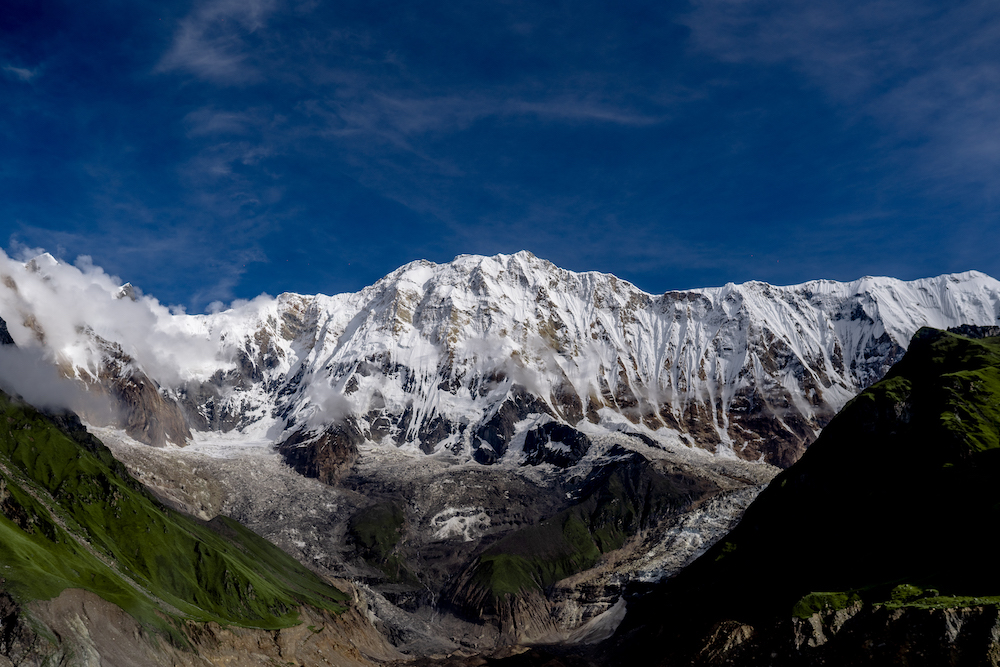
The Annapurna base camp trek is one of the most popular treks in the world. Trek to Annapurna base camp is an extraordinary adventure into the glacial heart of the western Himalayas. You will come face-to-face with the 10th highest mountain in the world, Mt. Annapurna 8091m. Annapurna Base Camp also offers the stunning views of Fishtail, Hiunchuli, Annapurna Massif, Dhaulagiri, Tilicho, Pisang, Pungda Danda, in addition to numerous other peaks.
Annapurna Base Camp Trek, ABC is one of the most popular hikes in the world. It’s truly a trip of a lifetime experience and lies at an elevation of 4130m.
The Annapurna Base Camp Trek, is a journey of dreams for mountain climbers. It is a journey that begins at a station called Annapurna Base Camp. From here, the journey to touch the majestic peak of Annapurna commences. However, for trekkers, the Annapurna Base Camp itself is a destination. It is a place nestled amidst the foothills of the Annapurna mountain range, an otherworldly landscape where the golden rays of the sun touch the summit of Annapurna early in the morning. Here, as the night’s frost melts in the morning sun and flows down the slopes of the Himalayas, it meets the Modi River with a musical sound. There, nestled in the lap of the Himalayas, are a few hotels that blend seamlessly with the Him0drialayan surroundings. They offer travelers’ smiles, tales of friendship, and the sentiments of beautiful journeys.The Annapurna Base Camp is defined not only as a place but also as an expression of emotions that rise above the definition of a location.
In this sixth episode of Heaven is Myth Nepal is Real season 3, we are going to the same land which has managed to make a home in the hearts of thousands of mountaineers and millions of trekkers. This trip to Annapurna Base Camp.
Due to continuous rainfall and flood-related news, the journey is much more challenging than before. Traveling in such times is more difficult than at other times. However, despite the hardships, you bring encouragement to the viewers by consistently sharing videos of new places every month. Four of us started the journey to Annapurna Base Camp.

Kathmandu was left behind. The city’s hustle and bustle have faded, and upon reaching Thankot, you enter the Prithvi Highway.
Everyone is well aware that for several years, there have been ongoing improvements on the Prithvi Highway. However, due to work not being completed on time, people have been enduring inconvenience. Because of the rainy season, the road has deteriorated significantly over the past few months. Landslides and mudslides pose a risk on both uphill and downhill sections, increasing the chances of minor and major accidents. Therefore, while embarking on a journey, travelers themselves must exercise caution.
The “Nepal 8th Wonder” team, while exploring, reached Sikre Khola located in Dhading, while we encountered the challenging and rough road of Kathmandu, making the journey even more adventurous.
The city of lakes, Pokhara, was the destination on the first day. Even though the distance from the road is only 250 kilometers, it takes travelers an entire day to reach Pokhara due to poor road management. The road, which serves as a major gateway to tourism, lacks proper maintenance, leading to inconvenience for both Nepali citizens and tourists. The hope is that in the future, the waiting period will bring us an opportunity for happiness as well.
Traveling is pursued either for the joy it brings or with the aim of adding novelty to a life that might have settled into a routine. However, the current state of the roads often dampens the excitement of the first day of a journey. Within Nepal lies an endless expanse to explore, full of untold stories. But the lack of well-maintained roads connects not only the places but also the narratives to the travelers. Roads are not only crucial for tourism but also an essential aspect of human life. Ensuring easy access to it ensures not just tourism development but also overall progress for the country.
After having a meal in Muglin, the journey continued towards Damauli. The road was still about 50 kilometers of dusty path to Damauli. The road ahead was filled with dust, and even after covering some distance in that dusty environment, there wasn’t much to see. Struggling through the dust, we pushed forward towards our destination.

After changing the road from Damauli to Begnas, there was some relief. The wind wasn’t covered with much of the heavy dust like it was previously..
After traveling for a while, we saw people who were on their way to catch fish in the river. We noticed the lush greenery around. Even though the road was rough, we witnessed the charm of the countryside. It brought a little joy to our hearts. As the journey continued, we observed rice fields in the terraced hillsides. The small ponds filled by rainwater were a captivating sight. Some villages seemed to have a distinct cultural ambiance.
After crossing the Simle Bridge and moving ahead for a while, we got a chance to have a conversation with a traffic police officer.
Between the wide fields and moving ahead along the road, we entered a jungle. On both sides of the road, dried leaves lay on the uneven ground. The absence of tire tracks made the road serene. From Damauli to Begnas Lake, we passed through places like Damauli, Duipiple, Parewa Danda, Neupane Besi, and Deurali. After a short while, we spotted a small settlement. Leaving it behind, we continued towards Pokhara.
After a while, we reached Deurali and spotted a signboard indicating the direction towards Begnas. Following the guidance of the signboard, we continued our journey towards Begnas Lake. We also followed that same signboard.
As the evening fell, we caught sight of the vast Begnas Lake ahead of us. Known as Nepal’s third-largest lake, Begnas has expanded in its enchanting beauty, becoming a favorite destination for hundreds of thousands of tourists. Its immense size had the power to encapsulate the joy of countless tourists within itself. The understanding of the happiness of these numerous travelers became evident. Feeling absorbed by the vastness of Begnas, we continued our journey towards Pokhara.
The second day in Pokhara had moments when it seemed both clear and cloudy. Partial glimpses of the Himalayas appeared now and then throughout the day. The sky was occasionally veiled by clouds, and at times, it would clear up just as quickly. It felt as if Pokhara was playing a game of hide-and-seek with us, teasing us with the views it would intermittently reveal and conceal.
After having morning tea, we left Lakeside. We encountered young individuals who were preparing for the British Army; they were marching along the road with heavy backpacks. Not long after leaving Lakeside, we got onto a scooter and traveled down the beautiful Pokhara-Baglung highway.
The Pokhara-Baglung highway is 72 kilometers long, starting about zero kilometer from Pokhara and ending at Baglung Municipality. This highway encompasses several places like Kusma Bazaar, Nayapul, Dimuwa Bazaar, Mal Dhunga, Purano Jar, Armadi, and Chamarke is a section of the Pushpalal Highway. It’s known for its well-organized and accessible construction. Over the years, as this road has improved, it has made the journey to places like Kusma and Mustang easier for both tourists and the general public.
As we were traveling the road gradually led towards Lumle, making it quite scenic. Despite the monsoon season, we didn’t encounter any rainfall that required us to stop. Since our plan was to reach our destination by evening, we weren’t deterred by occasional rain. Due to these reasons, the cool breeze outside the vehicle provided a refreshing sensation, keeping us in high spirits throughout the journey. This song echoed in our minds “Lumle Ko Hawale”.
The road remained pleasant for quite some time. Alongside the road from the hills, there was a small waterfall cascading down the slopes called Hungtu Waterfall. We changed our vehicle and after a while, we continued our journey with renewed enthusiasm, knowing that our destination was getting closer as the car moved forward.
At times, the road became steep and rugged. We encountered small streams running along the road. After approximately half an hour of travel, we reached Jhinu.

The suspension bridge over the Modi River, known as the Jholunge Pul, is quite captivating yet intimidating for travelers due to its swaying nature. As you walk in the middle of the bridge and look down, it can be quite thrilling and somewhat scary, as the river appears distant below. The sensation can be reminiscent of a roller coaster for some.
On the first day of the journey, we had to walk up the stairs. We knew that Jhinu was near, so the body did not complain.
A plan was made to reach the hot springs of Jhinu to remove the fatigue of two days. It is said that sitting in naturally grown hot water brings many benefits to the body. We also spent some time in the hot water, which has healing properties for skin diseases and body pains. Fatigue disappeared in a moment.
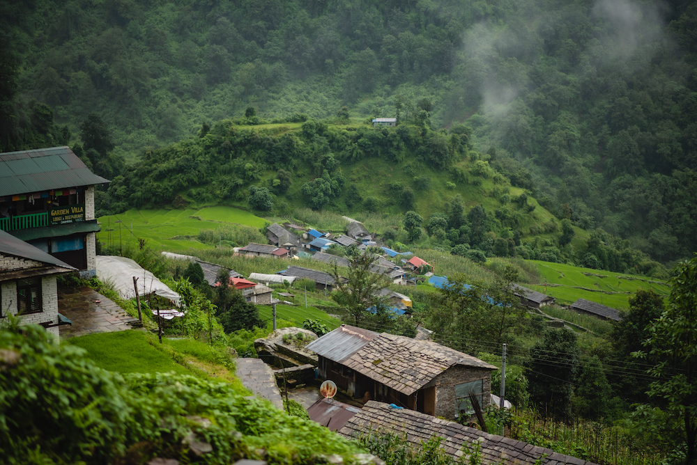
Situated at an altitude of around 1700 meters above sea level, Jhinu lies amidst the hills, offering a unique perspective of life away from the hustle and bustle of the city. Although the view of the Himalayas wasn’t visible due to the terrain, we had the chance to get a closer look at the local way of life. Even though Jhinu was not far from the road, the path was such that vehicles couldn’t reach all the way, requiring us to carry our belongings on our backs. Despite the effort, witnessing Jhinu, Chomrong, and other places above us felt like a rewarding experience. Unlike the cheaper costs one might find when closer to the road, Jhinu presented a distinct atmosphere that felt somewhat different.
The climb on the first day was very steep. From Jhinu to Chomrong there was a steep stone-printed staircase. When we walked uphill, we would feel the pain in our legs in no time. The weather was gloomy. The surrounding mountains were pierced by a small roar. The satisfaction was that it did not rain.

After a brief rest in the upper Jhinu, the journey resumed. The overcast weather had still kept the sky from clearing. We were ascending from an elevation of 1700 meters to 2200 meters. As we climbed up, Chomrong was visible near the hilltop, but the very steep way was standing right in front of us .
After crossing Taulung Danda at an elevation of 2160 meters above sea level, we reach Chomrong. We were feeling hungry, and not caring much about food, we ate noodles along the way.
While ascending, we spotted a black dog on the trail. Meeting a dog on the trekking path is not an uncommon occurrence for those venturing on a hike. Dogs that are found in the hilly regions often accompany trekkers for a stretch of their journey, following them until a certain point. That black dog also accompanied us until Chomrong.
Upon reaching Chomrong, the weather had become cloudy and misty. The coldness brought by Fog kept hitting the body again and again. We were disappointed that the day was cloudy and happy that we were nearing the place to eat.
In the 21st century, technology-driven fundamental necessities have emerged, leading every individual to seek connection with technology. Furthermore, there is a growing need for reliable networks even in remote areas. During travels, in case of health issues or emergencies, we search for someone to call beforehand. Nepal Telecom has extended its services to even these challenging terrains, ensuring connectivity and serving the nation and its people effectively.
From Chomrong, the descent towards Sinuwa began with waterfalls cascading down. We hurriedly took out the raincoat from the bag. Keeping our bodies and bags dry, we set off and continued ahead towards Sinuwa. Despite the challenges of traveling in the rain, the difficulty of the journey in the monsoon was once again present in our minds as we progressed.
To reach Sinuwa from Chomrong, one must first climb a steep uphill. Following that, another steep ascent is required before descending once again. The uphill climb can be quite challenging, especially for those who find it difficult to tolerate high altitudes. This path can be quite arduous for such individuals.
Stopping on the way and resting for a while, we started to trek ahead along the path. As the road was damaged in the middle, the local brothers were building the road.
Foreign tourists have also been encountered on the road. The Annapurna Base Camp trail has gained popularity not only among Nepali trekkers but also among foreign tourists. This route has made a significant contribution to the country’s tourism sector by attracting thousands of domestic and international tourists every year.
When we started climbing after having our meal, it was the beginning of the second half of the day. The steep way had not left us alone even since the previous day.
During the monsoon season, it can be quite challenging to trek with Raincoat. However, despite the difficult terrain, there are some beautiful aspects of Monsoon as well. The hills that had been concealed by mist now appear mystical and enchanting due to the rain. And the beauty of nature’s creations touches the senses, leaving an indelible impression on the observer.

In terms of height, Chomrong is 2170 meters above sea level and Sinuwa is only 210 meters above sea level. But it takes a long time to reach the top of Sinuwa because you have to go downhill first and then climb up again.
In the morning of the third day, the weather was clear. A little further on, we saw the Machhapuchhre mountain standing with a ridge connected to the mountain. The elusive fish tail with a head like a fish tail looked even more attractive in the yellow rays of the sun. On its upper side, Annapurna III, Gandharva Chuli and Himchuli were showing their presence from behind the mountain wall. A glimpse of the mountains gave us incomparable happiness after walking in a rush for two days.
Descending towards Dovan from Upper Sinuwa, the path might not involve such steep ascents as in the previous days. However, due to the presence of water and mud caused by rain, the trail could have become muddy and slippery. This might have made the journey challenging despite the absence of significant uphill climbs.
We were delighted to be able to walk on the small rocks that had flowed down into the mountains. The steepway, the downhill and the straight way were all coming in turn. The chirping of birds in the forest was constant, but the sound of the river sometimes drowned it out with its own voice. We moved forward looking at the beautiful beauty of nature.
We were about to reach Bamboo for lunch. It is said that a Rai person from Darjeeling had named this place. Since there are many Bamboo shoots available in the area, and the people there primarily make products like Mandro, Gundri, and Bhakari from these Bamboo shoots, he named the place “Byambu”. Over time, “Byambu” transformed into “Bamboo” due to Nepali influence. Currently, there are seven hotels in this area, and Nepali people are charged 550 rupees per person for meals.
The body was hungry and tired after walking all day in the waterfall. We rested on bamboo for a while.
After the rain stopped while eating, the team again proceeded to meet Dovan.

You had to balance a lot to walk on the steep road with flowing water. It was difficult to carry a camera and other things in hand, and one had to be careful about how to protect the camera from water.
We were happy that there was water, but that happiness could not last for long. We were forced to wear raincoats after some time.
Located at an elevation of 2505 meters above sea level, Dovan serves as a well-equipped resting place for tourists. With good arrangements for food and accommodation, this spot attracts thousands of tourists every year during the tourism season.
We rested in Dovan. The warm tea filled our cold bodies with warmth. Nearby, the waterfalls from the hills flowed rapidly, which got mixed with Modi Khola. It reminded us of the destination again. Remembering the destination, we filled our bags together and moved forward again.
When we reached lower Dovan, we left behind the large waterfalls. There were several places along the way where the path was made easier, and a wooden bridge had been laid across the rocky stream. The sound of those intense waterfalls and cascades was so loud that we couldn’t even hear each other speak, let alone listen to someone else. However, as we got used to it, even within that loud noise, there was a sense of tranquility.

In the sequence of our journey, we reached the Ponjyem Nyembra Temple. Situated beside a waterfall, the temple had a waterfall with 108 cascades, as our local guide informed us. It is said that initially, there used to be sheep folds in this area. One day the people bringing the sheep shed littered this place and soon the whole place was covered with fog.
Those who brought the sheep didn’t even know where the sheep had gone. After that, milk was seen flowing in the side waterfalls. And after the clouds slowly disappeared, the waterfall turned into water again. Then the people who brought Sheep Folds have started worshiping it as a place of deity because there is divine power here. At present, the Ponjyem Nyembra temple has been established at that place.
If the weather is clear, the neighboring Mardi footpath can be seen on the opposite side of Himalaya. At present there are 3 lodges in this place which have good food and accommodation. This place has also become somewhat convenient due to the easy connection of the network. Nepal Telecom has been fulfilling its mission of connecting the country to the world since its inception by providing services to such inconvenient places.
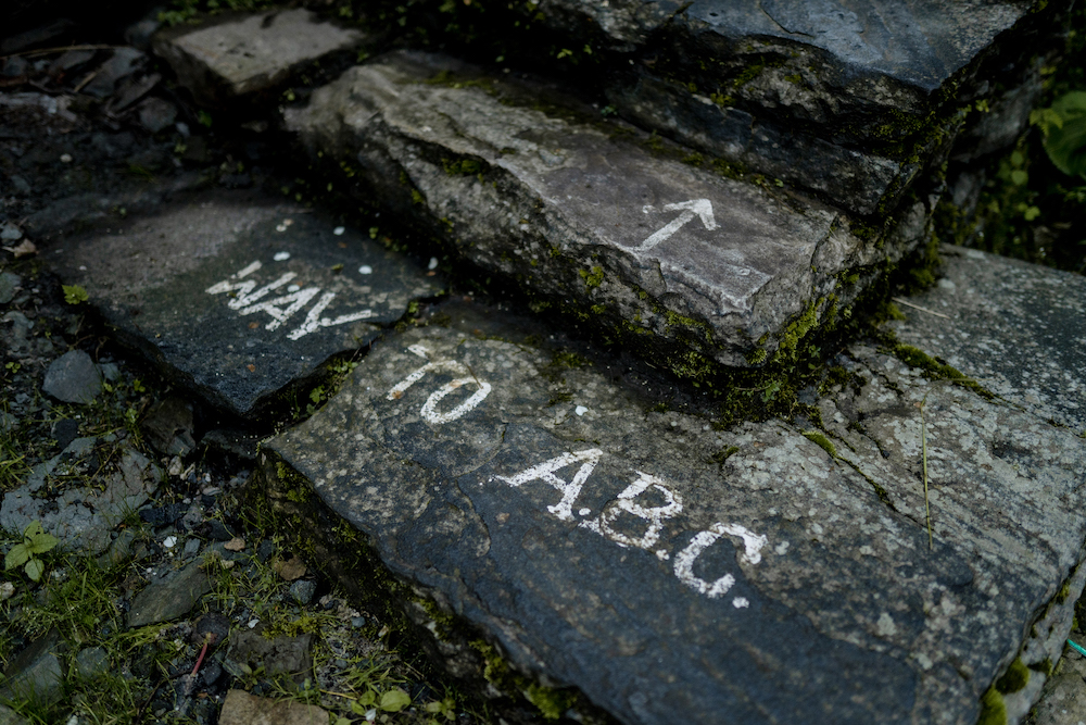
The weather also worsened while trekking from the Himalaya towards Deurali. When pointing out some of the special features of the Annapurna trail, the locality boards here cannot be missed. There is a road sign and all the necessary information in every tea house or any lost place on the way. This trail is very suitable for people who cannot walk much as tea houses are also located near other trails.
The road from Himalayas to Deurali is considered to be a bit of a risky road in this region. When the weather is hot, it can be seen that we are traveling at the foot of a big mountain and the rock falling zone boards are placed on the side. It is advisable to travel with caution while traveling in this area.
After a short walk from the Himalaya, you will reach the Hinku Cave. A resting place for hikers has been made in the cave under the rock on a big hill. Trekkers walking towards the Annapurna base camp rest for a while and observe the beauty of the mountain.
Small bridges made of iron and wood were built so that people could easily cross the rivers. The team headed towards Deurali, leaving behind the river flowing under that bridge.
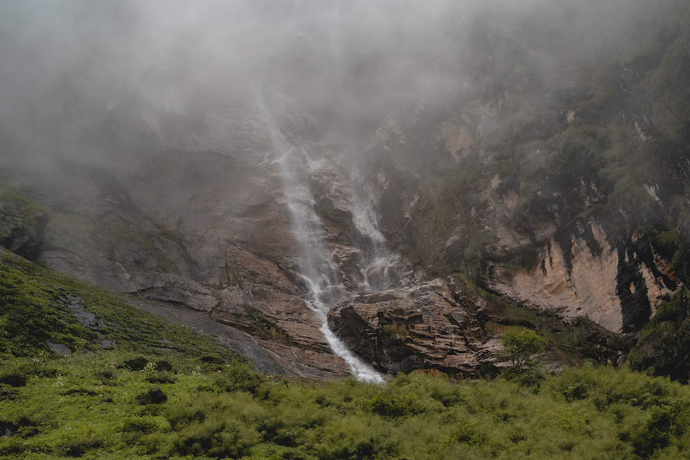
Reaching Deurali at a height of 3200 meters above sea level, a huge waterfall can be seen a few meters above. Looking at it, it seems that the most worthy artist in the world is water, which finds a way in the rocks it flows in such a way that those stones become artistic.
It takes about 4 hours to reach Annapurna base camp from Deurali. When the weather is clear, you can see the art of Lord Buddha naturally formed on the mountain wall from this place. In Deurali, where there are only 4 hotels, tourists traveling to Annapurna base camp spend one night and head to the base camp the next day.
After having lunch in Deurali, rainfall started again. We followed Modi Khola, which had been walking together since the first day, and continued to meet the Machhapuchhre base camp. It felt like the whole world was covered in fog. We couldn’t even see the route ahead of us because of the fog.
At that time, we thought we wouldn’t see any Himalayas during this trip. But to put an end to that disappointment, the hope that the mountains will open with the light of tomorrow was also alive. So it encouraged us to move forward.

The ice on the road indicated that the Machhapuchhre base camp was approaching. We have learned to be happy with the things that can be seen a few meters away because the fog was so thick previously.
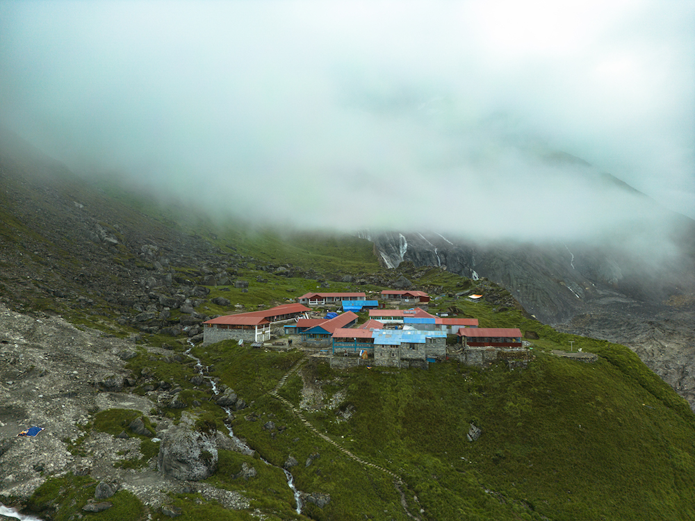
Machhapuchhre Base Camp or MBC is located at an altitude of 3700 meters above sea level. There are only 5 lodges in this place in the lap of the 6693 meters high Machhapuchhre Himal. When the weather is clear, the travelers can see the beautiful view of Annapurna snow range including Machhapuchhre Himal from this place. After climbing up from MBC, there is a small route, and ABC can be reached by following it.
Even after arriving at such a beautiful place, we couldn’t even have a glimpse of the mountains yet. If it’s a clear day, you have to walk in this place wearing glasses because the snow and sun will burn your eyes. Anyways, we were wandering around looking at the green grass.
When we reached Annapurna base camp, some buds of hope appeared in our mind. The clouds which were there for the past two days cleared a bit. The mind felt a moment of immense satisfaction. All the trekkers who reached the base camp were shocked. Nature did not let the hard work of 4 days go in vain. We were really happy.
In the morning, Annapurna Base Camp at a height of 4130 meters above sea level stood with the beauty of the beautiful Machhapuchhre, Gandarva Chuli, Annapurna III, Gangapurna, Annapurna I, Bahrashikhar, Annapurna South and Himchuli. The warm rays of the sun slowly spread over the mountains and green hills. We got lost in that beauty in such a way that the beauty itself became an addiction.
Annapurna Base Camp, which can be reached in 4 days of continuous walking, welcomes thousands of guests every year. The message written, “Come as a friend, return as a family” on the signboard placed in Machhapuchhre Base Camp is indeed true. When you reach Annapurna Base Camp, you will experience it firsthand.
Standing at the Annapurna base camp that day, our team was gathering memories and experiences that will last a lifetime. We kept disappearing in the surroundings of Annapurna, humming to ourselves that these memories will be our friends in the later part of our lives.
Even in such a beautiful place there is one essential thing missing and that is nothing but the problem of mobile networks. Locals of the Annapurna base camp who do not have any network said: Although there is some discomfort at present, we are confident that Nepal Telecom’s connection will come to ABC in the future.
The trip to Annapurna base camp was reached by a one day scooter ride along with a 4 days trek & It was very exciting. Rain falls, a thick curtain of fog, the murmur of the river, the chirping of the birds, the story of the Ponjyem Nyembra temple and the sheepfold, as well as the Hinku Cave, countless waterfalls and mountains became our companions on the journey.

Lalit Gurung Dai who would carry our bags to make us comfortable throughout the journey. We would like to thank from the bottom of our hearts all the hotel managers and sponsors who financially supported our trip.
There is hardly any Nepali who has not heard about Annapurna Base Camp, but there are still many people who have not been able to reach there. For those people who want to reach but have not been able to reach Annapurna Base Camp in this way, we have shown it through this video.
Thanking everyone for watching the video so far, we have put the name and contact information of all the hotels here. Keep it as a screenshot. It will be easy to pre-book during the season.
We will meet again in the next episode. Hope you will wait.
Comments are closed.