

 – 4 Days trip from Kathmandu")
Being famous and beautiful don’t always have a direct connection. Only a few limited places are recognized as Nepal, but there are many places that may not be famous but are beautiful. Every time you visit undiscovered places, you see a Nepal that has not been seen before. Stories unheard of are encountered, and life unfolds in its own rhythm. And every time, Nepal is much larger and more extensive than what we understand and see. Opportunities to understand that are obtained when we reach places not heard of. Exactly like this, we recently had the opportunity to go to Dudhkunda in Solukhumbu district.
Solu Khumbu is always associated with Mount Everest. Spread over an area of 3,312 square kilometres in the SoluKhumbu district, it annually attracts thousands of mountaineers from around the world, making it the most sought-after destination. In the SoluKhumbu district itself, places like Dudhkunda, which are not only majestic in height but also remarkably beautiful in their own right, exist. While other destinations may only be accessible through strenuous climbs, Dudhkunda is a place where we can easily reach, without the need for mountaineering skills, and where the main attraction is just a short distance away. Solukhumbu lifestyle, hospitality, and scenery, not often seen on the map, can be experienced up close, making it a better option for those who seek different experiences from their daily routine. What could be a better choice than reaching places that are not easily visible from your daily newspaper?
In season 3 episode 7 of “Heaven is Myth, Nepal is Real” We are heading to Solu Khumbu, a region not so famous. A region enriched with natural and religious beliefs. We are heading to the foot of Numbur Himal, where one can witness the vast snow-capped peaks of the mighty Himalayas, where the Numbur River flows like pearls and Dudhkunda, with its crystal-clear water, stands as a divine pond. We are again enchanted by the three rounds of natural beauty, chanting mantras, and the boundless possibilities that accompany us.”

The new day dawned with the energy of a fresh beginning, bathed in the rays of the sun. As always, Kathmandu was bustling with activity in its unique way. The special thing about humans here is that they have found a basis for survival even in the hustle and bustle. At other times, we too used to be a part of this daily routine. But this time, our story was different. We emerged with the enthusiasm of a new journey, riding on a Honda Grazia on the Ring Road. A different kind of excitement than others. The excitement of leaving behind the artificial city and getting closer to nature. We advanced ahead on the well-organised roads of Kathmandu, leaving the chaos behind. The airport was left behind, then the traffic jam in Koteshwor was left behind, and we left behind the next buildings, overhead bridges, and the organised life for a few days right there. A few moments later, we were on the road from the capital that led to Bhaktapur and Banepa leaving the small geography with vast opportunities. As we reached Dhulikhel, the message of the festival’s arrival was being conveyed by each breath.
After covering about 20 kilometres from the capital, we decided to stop in Dhulikhel for a snack. Dhulikhel is divided by two major highways, and we chose to take the BP Highway, leaving behind the Arniko Highway. After having our snack, we took a short break for rest before continuing our journey. Dhulikhel, located within the Kavrepalanchok District, is an important place for Kathmandu Valley. Here, Dhulikhel Hospital, Kathmandu University, some tourist destinations, and other places contribute to the significance of Dhulikhel.
Dhulikhel is situated on the eastern edge of the Kathmandu Valley. We experienced a slightly cleaner and less smoky environment compared to Kathmandu. The journey had started from Banepa on the BP Highway. The timing was perfect for travellers, as it was the season for harvesting rice, blooming of marigold flowers, and the sun casting a warm glow. It was the time of festive joy and celebration, the time of Sharad Ritu (autumn). Perhaps, Dashain and other festivals were around the corner, as the BP Highway appeared busier than usual. This road, connecting Kathmandu to the eastern Terai, has always been relatively more organised, probably due to its purpose of linking the capital with the eastern Terai. From Banepa to Bardibas, the total length of this highway is 158 kilometres, and it was constructed with the support of the Japanese government. Its impact, however, goes beyond just facilitating travellers; it directly influences the daily lives of the people residing along its route.
The extensive greenery, the agricultural fields were seen in every corner, and the modern roads connecting them, wasn’t it enough for being happy? As we lose ourselves in these scenes, we realize that we reached Sindhuli District, without even noticing it. With an area of 2,491 square kilometers, Sindhuli District unfolds its charm with Krishna Vikram Thapa’s song “Sinduli Gadhi Ghumer Herda, Suntali Mai Kati Po Ramro Darbar ” resonating in our minds. Sinduli is a region with a blend of the inner Terai and hilly areas. Due to this, we found ourselves traveling on straight roads and sometimes on windy roads. After covering a distance of about 95 kilometers from Kathmandu, we decided to stop in Mulkot, Sindhuli District, to have our meals.
From Mulkot, the Sun Koshi River flowed gracefully with its gentle current. Due to the development of the highway, there were several hotels and resorts in the area. Mulkot had become a brief resting place for those travelling to Eastern Nepal, ensuring various facilities for a short break. On one side was the Sun Koshi, meandering at its own pace, and on the other side was the winding road section. It was a captivating scene in itself. The winding road section of the BP Highway was not only picturesque but also well-maintained, even more so than other highways. This fact emphasised that development is possible even in challenging topography.

After passing through the Mulkot Bazaar, we began a continuous ascent. If any traveller journeys along this highway, they will come across a place in this section where thousands of mirrors are placed on the sides of the road. Despite the good condition of the road, this winding road section is known for frequent accidents. Hoping to avoid such accidents, Seti Devi Temple is adorned with mirrors, offering them as a dedication. However, the countless mirrors serve as a meaningful warning to travellers about the risks of accidents. After passing Seti Devi Temple, the ascent began gradually. Buses and Tata Sumos were seen coming and going in a sequence. We were moving at our own pace, steadily advancing ahead. We were not in a hurry, and it was clear that overtaking on this section of the road was not advisable, which we understood well.
After reaching Khurkot, we had to take a turn towards the left to reach Okhaldhunga, leaving the BP Highway. When observing Khurkot Bazaar, it was as bustling as some cities. There seemed to be hospitals, well-established hotels, and thriving business opportunities. Has such a transformation occurred overnight, or has it been a gradual process? Any change requires time, but how much time? This uncertainty remains!
The lifestyle along the road to Okhaldhunga was quite different from the hustle and bustle of the market. Between two hills flowed the Sun Koshi River, with a road on one side and the other side adorned with terraced settlements and fields. These two hills were connected only by a suspension bridge. We wondered, if the suspension bridge were not there, how far behind would that world be? While the places touched by the highway were developed, other areas remained in such serene shades. In these shades, we were also looking for Nepal, hidden in the shadows. We still had about a hundred kilometers of travel to reach Okhaldhunga, and the road leading there was winding through various places, untouched and unorganised.
At some places, we saw water flowing through the road. We saw some bridges being constructed, and it didn’t seem like a quick task. However, the travellers and the locals here have to endure such difficulties. But then again, we accepted every joy and sorrow that came our way, acknowledging the reality of the situation. As the day gradually turned into night, the sky became overcast, and light rain started to fall. We couldn’t predict the whims of the weather. After a short while, we crossed Sindhuli District and entered Ghurmi of Katari that falls in Udayapur district of Nepal.

The Sun Koshi Bridge connects Udayapur and Okhaldhunga. After crossing the bridge, we entered Okhaldhunga district. Situated at an altitude of 1561 metres above sea level and spreading across 1,074 square kilometres, Okhaldhunga offered a different climate compared to Sindhuli. In each place, the hilly terrain had been carved through by hardworking locals, and the absence of roads was a common sight. People were herding livestock back to their homes, and the fields were becoming quiet. The sky, painted in deep shades of orange, showcased its beauty. Despite the decreasing visibility in the twilight, we continued our journey, leaving the darkness behind. Our day-long journey from Kathmandu had finally brought us to Okhaldhunga Bazaar.
Okhaldhunga Bazaar woke up before we did. There was a new rhythm and a new environment in the new morning. We weren’t familiar with such an environment. Although we had NTC network with us, that helped us to know about Okhaldhunga. Siddhicharan Municipality, within Okhaldhunga Bazaar, is inhabited by people from various communities such as Kshetri, Tamang, Brahmin, Rai, Newar, and other ethnic groups. Seeing the united lifestyle among people of different castes and ethnicities, we were fascinated. We have witnessed numerous examples of unity in diversity over here.
During the Mahabharata era, Bhima came here and harvested rice, leading to the place being named Okhaldhunga. Later, the renowned poet Siddhicharan Shrestha popularised the name ‘Okhaldhunga’ in the literary world through his poem ‘Mero Pyaro Okhaldhunga.’ In his honor, the municipality was named Siddhicharan. Okhaldhunga, situated at an altitude of 1561 meters above sea level, covers an area of 1,074 square kilometres. Due to its unique geography, it has a diverse landscape with lush Dhudhkoshi and Sun Koshi river flowing through it. Okhaldhunga is known for its agricultural abundance, with terraced fields climbing up the hills from the market. We were delighted to witness the agricultural prosperity while travelling on the road that started after the construction of the Sun Koshi Bridge. The network provided us with the essential information and services required for sustainable livelihoods. After seeing such a vibrant market and livelihood along the way we stopped at Thadey Bazaar to have our breakfast.
In the chilly weather, thukpa provided some relief. After leaving the place where we had thukpa, we entered Solukhumbu District. This time, the understanding of having a fresh start was felt. Many things have changed, and this time, instead of going to Pikey Peak, we headed towards Dudhkunda. To reach Dudhkunda, we had to take a turn from Dhap Bazaar. Until this point, our journey was familiar to us. However, after leaving Dhap Bazaar, we were entirely new travellers to this destination. A new chapter began from here, a place we had never visited before.
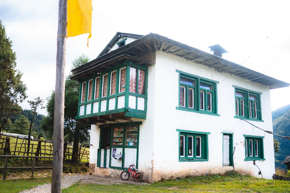
We had experienced a kind of lifestyle in the lower parts of Sindhuli and Okhaldhunga, but the life and environment here were significantly different. Because we used to travel in the lower region of Solukhumbu. When we say Solukhumbu, in our minds, it’s all about the Himalayas. Inside Solukhumbu, there are many places, especially in the lower part, where the Rai community holds dominance, beyond the Himalayas, it’s the domain of the Sherpas. The higher we climbed, the temperature gradient was also changing rapidly. Here, the houses were different from those in the lower region. Houses made of tin and wood. The roofs of those houses were designed not just for aesthetic appeal but for the practical purpose of resisting the extreme cold. These were the kinds of houses that made us realise that we couldn’t just pass by without being intrigued.
Eventually, we reached Patal Bazaar. From Patal Bazaar, the disappointment expressed by the sky, showing some glimpses of the Himalayas, was akin to a melancholic soul. However, we didn’t let ourselves feel disheartened. We encountered so many interesting and captivating things on our journey that even if we were imprisoned, we couldn’t capture everything. The small and seemingly insignificant details were fascinating. Like the humming of insects that transformed the environment into something melodic. Empty but musical. In these moments, the still mind found joy and contentment in every fleeting second. But we were travellers who found beauty in the unusual and charming. What if the flickering of a firefly doesn’t seem enchanting? What if the cold doesn’t provide relief even for a moment in these chilling times? What if we always travel from such roads? That’s the difference we encountered between travellers and residents. Because we were travelers, every moment became significant for us. Until we accumulate enough of those moments, we must live each one as profoundly as the last.
After leaving Patal Bazaar, we entered Salme Bazaar, which was quite close to Salleri. From Salme Bazaar, we drove towards the central hub of Solu-Khumbu, Salleri. Beneath the hills near Salleri, the Sholu River flowed gracefully, eventually joining the Dudh Koshi River. Not only serving irrigation and agriculture but also contributing to the livelihood of the local people, the Sholu River has the potential to generate 25.3 megawatts of hydroelectric power. After reaching Salleri, we continued our journey and spread across a small settlement. This area, with more than 1600 households, falls within the Solu Dudh Kunda Municipality.
After crossing the Salleri region, the condition of the road gradually began to erode. Here too, our trusty companion, the Honda Grazia was with us. After Salleri, we reached Phaplu. Phaplu is a significant location for travellers exploring the Dudhkunda or Solu region because it has an airport. For tourists coming to explore the Dudhkunda region, Phaplu holds immense importance. Not only is it a convenient stop for tourists, but it also serves as a vital connection to the capital, as it is equipped with an airstrip. This airport in Phaplu is strategically connected to Kathmandu and Lukla. It serves as a crucial link for those heading to the Dudhkunda area. Travellers wishing to reach Dudhkunda can easily fly from Kathmandu to Phaplu and then proceed with their journey from Phaplu itself.
After crossing the Phalpu Airport, the road became increasingly challenging. The flow of water from the Himalayan springs, resembling the gentle drizzle of dewdrops, consistently dampened our path, making it as slippery as melting snow. In some places, the road was eroded, and we had to cautiously navigate through the narrow spaces between the fallen rocks. We were driving with utmost struggle. Nevertheless, sometimes we stopped ourselves from drowning in the sound of the flowing river, losing all our senses of time. Still we were hungry and Ringmu village was not far from us. After a few moments of driving we discovered houses with similar structure and guessed that might be the Ringmu village.
Another place within the Solududhkunda Municipality was Ringmu. We had ascended to an altitude of around 2800 metres above sea level. Ringmu had its own unique charm, standing out from other areas. The houses there had a distinct character. While many regions had suffered from deforestation, Ringmu had managed to preserve its forested slopes. Even though there were fewer houses, they were strategically placed, creating a beautiful landscape. We were on the verge of enjoying the simple and delicious local meals in the serene surroundings of Ringmu.
We were about to enjoy our meals long after travelling to Ringmu from Thadey Bazaar. The sky was adorned with swirling clouds. Ringmu was nestled between thick forests and hills, creating a picturesque landscape. Despite its small size, Ringmu emanated a sense of civilization even amidst the wilderness. The place felt remote, with the town centre having a cosy and compact feel. We went to explore the scenes until our food was served. Ringmu, despite being a small village, held great potential for tourism and agriculture. It had become a familiar stopover for those heading to Dudhkunda, contributing to its significance in the region. Spending our second day of the journey in Ringmu, we marvelled at the charm of this emerging destination.“
Morning from Okhaldhunga to Ringmu, we travelled continuously by scooter. Aftering waiting patiently for some time we finally had our meal. That day’s journey was only up to Ringmu. After eating, we were able to find tranquility by climbing uphill and getting lost in the beauty of Ringmu. In the evening, Numbur Himal on the left, Khatang Himal, and to the right, the Karyalung Himal, appeared from different perspectives, drawing closer from house to house. But, the clouds covered the view after a few days. In the love story between the earth and the sky, the mountain was innocent. It seemed more appropriate to rest than to wait in vain, as tomorrow’s journey was going to be more challenging than today’s.

In the morning, when we woke up, we felt very close to the Himalayas. The cool breeze, along with the greenery, brought new possibilities, new stories, and energy. As the sun rose, Ringmu was situated in the lap of the Himalayas. However, the weather was a bit turbulent. The threat of clouds persisted. Although there were only a few houses, Ringmu was a buzzing village. It is a familiar destination for travellers, having witnessed many mountaineers before entering the Everest region. The road section was gradually undergoing development. Thanks to NTC for connecting the people here with the world. The majority of the population here comprises Sherpas, Magars, and Dalits. Some engaged in small businesses, while many relied on agriculture and animal husbandry. At an altitude of 2800 metres, they experience two main types of crops throughout the year. The tradition of cultivating one field with potatoes and the other with wheat continues throughout the year. In Ringmu, the fragrance of the air was captivating. The surrounding trees, like ambrosial sentinels, provide a refreshing breeze. It was clear that the role of trees is indispensable, and from here, the forest plays a crucial role in the environment.
A few years ago, if someone wanted to go to Dudhkunda, they had no choice than travelling to base camp within the day. But now, a place to eat and stay have been established in Kamudanda. For this reason, without hesitating, we eagerly waited to stop our journey. Despite facing difficulties and eagerly waiting for three days, we finally set out to explore the charm and daily life of Ringmu. Despite the lack, the resilience of childhood, the maturity gained through struggle, and the maturity of the Himalayan terrain, these indescribable scenes accompanied us. Until then, with the sun occasionally peeking through the scattered clouds, we were observing the surroundings little by little. Our porter brother had also joined us. We started our trek towards Kamudanda, making it the main destination for that day.
For the past two days, Honda Grazia had been accompanying us from Kathmandu to Ringmu. But now, it was time for our walking journey. Only the road to Ringmu was suitable for vehicles. We prepared for the trek, leaving our companion here. The journey towards Dudhkunda had begun, and the sky was clear. The morning dew had made the trail slippery. The fragrance of the soil, the greenery, and the height looming over us accompanied our every step, inspiring us with enthusiasm for Dudhkunda. Passing through villages like Ringmu, Nuthala, Chulemo, Heva, Changa, Akang, and Deku, all located within the Takshindu, we advanced towards Nunthala from the village of Ringmu. Ahead on the trail, the information about each place, including the direction, the name of the place, the altitude from sea level, and the convenience for travellers such as dustbins and resting places, brought joy to our journey.

On the trail, small things like this continue to bring joy. Because we hadn’t encountered any major obstacles or found the luxury of a well-equipped city. We were getting closer to reality, leaving behind all the preconceptions! The more scenes, experiences, and stories people express without knowing, the more beautiful Nepal seems to be. And the reality is not that simple. This journey will reveal how challenging it is, but the inspiration to overcome those challenges comes from these small comforts and facilities.
While on a journey, continuous endurance is crucial. When fatigue sets in, finding a place to sit and rest becomes appealing. However, fatigue is temporary, and so is relief. Therefore, it is necessary to move forward in a balance between the two. After a brief rest on the Kerung Pati, feeling rejuvenated, we resumed our trek.
As we walked on the trail, the melodious sound of chirping birds became music to our ears. Seeing the stairs imprinted with stone, we felt as if we were on the terrain of Ghandruk. It felt like they it was stretched to infinity and we are destined to infinity too.The prayer flags with the inscription “ॐ मणि पद्मे हूँ” (Om Mani Padme Hum) were seen in every nook and corner. Even before this, we had seen well-maintained monasteries and stupas in this area.
In the Solukhumbu district, 21.5% of the population adheres to Buddhism. Buddhism teachings impart the wisdom of how to maintain inner peace and stability amidst the challenges of life. They teach that by reaching an internal state of tranquillity, one can navigate life’s ups and downs with resilience. Whenever we approach nature, we always contemplate staying inwardly focused. Thus, as we trek on the trail, we find that amid the external world, we are also engaged in exploring our inner world. Consequently, during the journey, our efforts are not solely directed towards the external world but perhaps more towards understanding our internal realm, making the trek a voyage of self-discovery.
In the morning, after having breakfast in Ringmu, we set out for Kamu Danda. Until reaching the place there were no places in between to stop and have a meal. It took quite some time to reach Kamu Danda, and by then, we were quite hungry. We found relief in having noodles. After enjoying noodles as our breakfast, we continued through the middle of the jungle, navigating the steep slopes of the trail that led to Kamu Danda. As far as the eye could see, there was no sign of settlement, nor any human-made infrastructure. Even for a brief moment, we were free from the constraints of society and societal bonds. Amidst the trees, rhododendrons, vines, and various vegetation, there was no competition. Everyone was struggling to survive on their own. The society and its bonds were not necessary here. It felt liberating to be momentarily free from societal struggles. Upon reaching such a place, the importance of being free becomes even more apparent. Yet, there are moments when a brief escape is necessary for one’s independence. The beauty of this freedom cannot be entirely captured in a picture; it is a beauty that can only be felt.
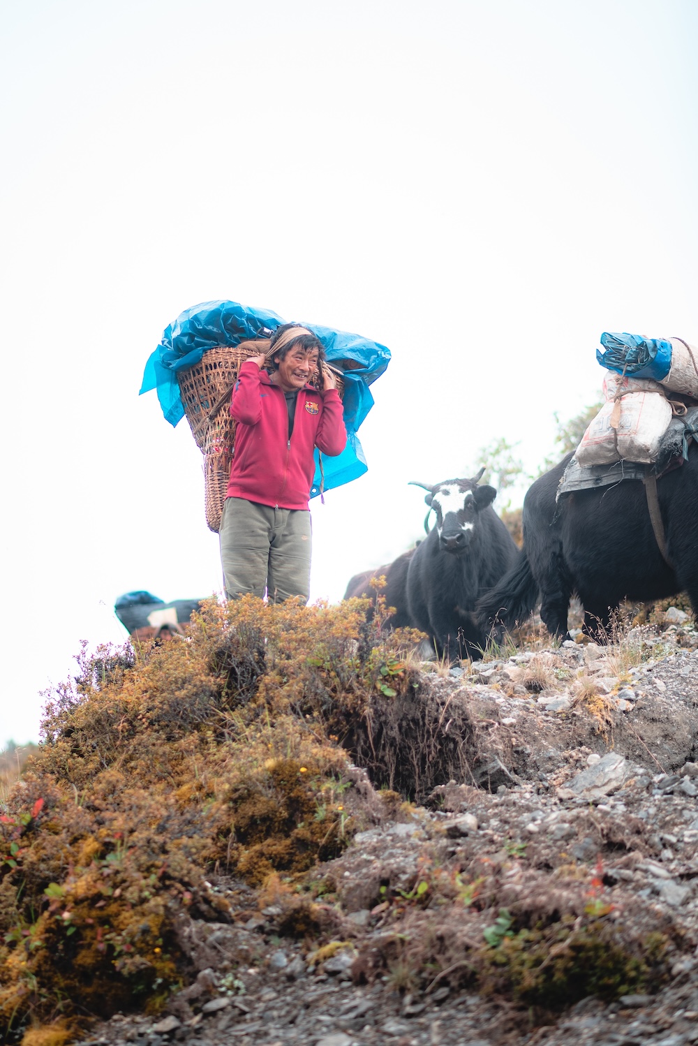
The trail to Kamodanda was like this. On the trail, we encountered a brother who used to import and export goods with the help of yak as there were no wide motorable roads; there was only a temporary provision for that purpose. Despite the challenges, the possibility of encountering such difficulties for our livelihood became a source of inspiration for us. We climbed uphill for four to five hours with determination. Mist covered the area densely. After climbing a steep hill a few times and crossing rocky and densely forested areas, we finally reached Kamodanda.
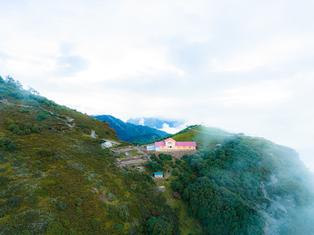
We had the opportunity to talk with our family, friends, and teammates although we were at an altitude of 3880m. The credit goes to NTC. In the past, we could not even imagine travelling here. But now, due to the good management of living facilities in Kamodanda, the journey has become somewhat easier. Clouds lingered on all four sides, resembling a river like Pokhara. It was a spectacle that fascinated us, and we were eager to explore the path behind the curtain. Despite the cold weather, we made noodles and enjoyed watching them simmer in the pot.

The experience of eating noodles while the sky opens up is like a small celebration, and there? What is the microcosm and where? When the gentle breeze touched us, it felt like the Himalayas had sent a message, and the fragrance of the open space. But the sky? The sky was completely clear. Today, we had come from Ringmu to Kamodanda, and tomorrow our destination was set for Saharsa Beni. And for today, the journey had come to a halt at Kamodanda.
The scene of the sun kissing the peaks of the Himalayas, we bid farewell to Birali. From Kamu Danda, in Solukhumbu, one could see some of the prominent Himalayan peaks. Peaks like Sagarmatha, Lhotse, Tamserku, Khatang, Kusum, and Kangaru, along with their majestic ridges, were visible. The distance to Numbur and Pike Peak, though quite far, could be covered in just a few steps. For tourists coming to observe Dudh Kunda, the community-built infrastructure in coordination with the department of forest provided easy services and facilities. The building also catered to the essential need of the travelers i.e. mobile network. Even at such altitudes, the reach of the NTC network made the journey of the tourists smoother, and Kamodanda had also made its mark as a place that connected with the world.
Our porter brother led us ahead towards the road. After having breakfast at Numbur Retreat, we set out, determined to reach Saharsabeni. As we started, the sequence of clouds coming and going continued. We accepted this and moved forward. Looking from above, the paths looked like tiny threads. We weren’t able to believe that we were so close to mountains. We also saw the plant of Lali Gurans, considered the national flower of Nepal. Unfortunately, it wasn’t the season for rhododendrons to bloom. On the trail, we encountered yaks, a special breed found in the Himalayan region. People collect wool from them, and their fine wool is used to make warm clothes. Dogs easily approach humans, making it easy for them to shepherd people. The relationship between humans and dogs is more profound than language, and it is stronger than emotions expressed in words. Captivated by the essence of this relationship, we moved forward on our journey, leaving behind the boundaries of fear and height. In such moments, the understanding of the scenery and destination becomes more profound, and the source of inspiration for the journey becomes more apparent.
Even in disappointment, the journey had taught us to find hope. Despite the disappointment and not seeing much, as we continued our journey, we swam amidst the clouds. All the scenes in front were obstructed. Although we were so close to the Himalayas, we couldn’t see them. Ahead, it was uncertain what awaited us. In such moments, a certain kind of spontaneous enthusiasm is generated in the mind. The enthusiasm mixed with fear kept us moving forward with curiosity and eagerness. In such moments, we hear the sound of a distant open space. Even though the path is unknown, we can hear the sound of a stream roaring in the chest of the mountain.In such moments, a kind of spontaneous enthusiasm arises in the mind, and even small steps are enough to make the journey successful.

The locals had made the path using stone imprints, making it easier for us to walk. How much more we had to walk and what kind of scenery awaited us ahead was uncertain. We were progressing as the path unfolded before us. The construction of the path, made easy for walking through the use of stone, was evident. We were reaching the same point wherever the path led. We were adapting to whatever the weather and seasons presented. We were consistently following the path set by nature. Whatever the weather and nature revealed, we embraced it, becoming the admirers and the biggest fans of it all.
The boy playing with the kites looked as cheerful as the flags fluttering in the Numbur Himal’s breeze. We had reached an elevation of 3,850 metres above sea level. There, we enjoyed snacks, rested a while, and then continued our uphill journey. The surrounding area was untouched, in its pristine natural state. It meant that no one had added or modified anything artificially. Whatever was there, it existed in its pure, natural form. The essence of the place was maintained in harmony with nature. What was there was as beautiful as nature intended it to be. Even in such a remote place, we were connected to the outside world through the NTC Network, making the most of technology to share our experiences with the broader community. After a few hours of uphill travel and a bit of descent, we joyfully reached Sahashbeni, a small pass in the foot of Numbur region. Beyond that, a network connection was not available, but that didn’t stop us from utilising the available network to share our experiences and connect with the wider world.
In a matter of a few hours, we had reached the foothills of the Numbur Himal. Standing at Saharsabeni, gazing at the vastness of the Numbur Himal, we contemplated the greatness of this moment. Although Solukhumbu is renowned worldwide, many overlook places like Numbur. The lack of extensive publicity might be due to limited information technology infrastructure. However, as information technology expands, it is certain that the promotion of such places will increase in the days to come.
The river Numbur flowed alongside Saharsa Beni with its swift current. This Numbur River, merging with the Ringmo River and the Ringmo River joining the Solu River, eventually contributes to the Dudh Koshi River. In the starting point of this vast journey situated near Saharsa Beni, profound questions emerged. As we settle down in this expansive journey, contemplating the heights we are striving for, the persistence we show for success every day, is that the truth? Or have we created an illusionary world ourselves? And what about what we perceive and feel, what is that? Ultimately, what is the truth, and what is the illusion?

The rain had been continuous throughout the night. When we woke up in the morning, there was no sign of the rain stopping. In that region, crossing water during heavy rain is extremely risky. Due to this, we realised that we might not be able to reach Dudhkunda on that day, as it was unsafe to cross the swollen river. The cold intensified when it rained, making it difficult for us to step outside in the morning. We stayed inside, fearing the cold.
The flow of the Numbur River near basecamp was increasing due to the rain. The surrounding scenery was obscured by the mist created by the rain. Although we couldn’t witness the sunrise near the Himalayas, there was a sense of anticipation that the rain would stop, and the sky would clear. After observing Dudhkunda from a distance, some foreign tourists had also arrived at the camp. The prospect of this place gaining more recognition filled our hearts with excitement. Moreover, the conversations with them were enjoyable and created a sense of camaraderie. Isn’t it true that a person who has been captivated by the beauty of nature can’t remain indifferent to nationality, language, or ideology?
We didn’t have a water-stopping tarp, and the increasing cold due to the rising temperature made us unable to cook noodles. In such situations where the weather itself does not favour us, we often find ourselves unable to do much. We can only wait patiently. During the journey, the address of how many days we will face adversity is uncertain. Therefore, on that day, we spent time with the locals who were tirelessly constructing buildings day and night.
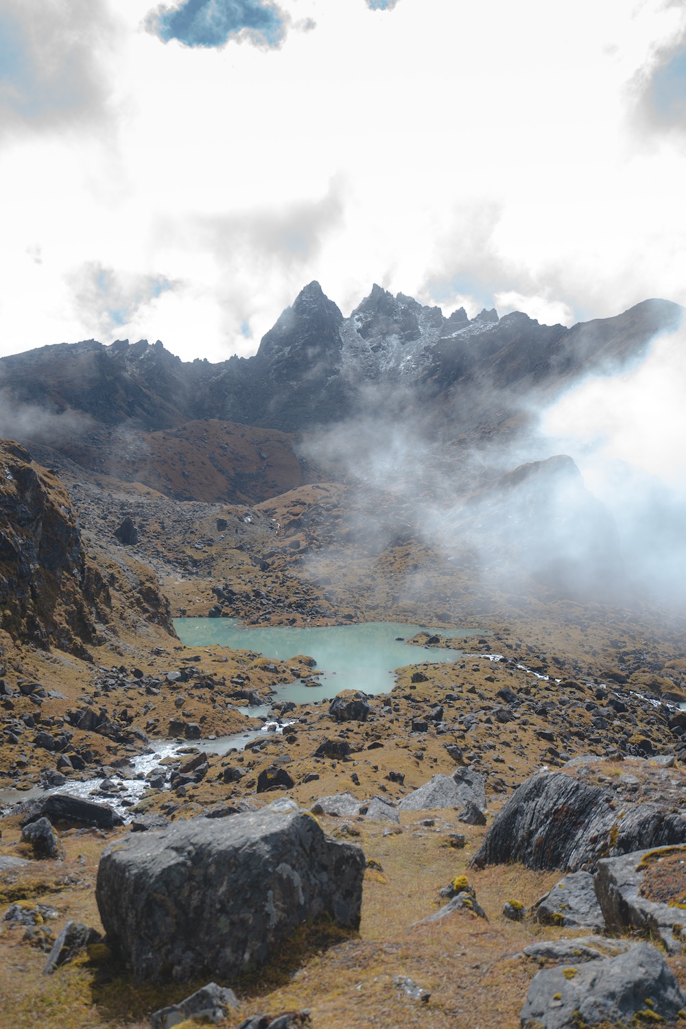
In the morning, without waiting for the sun, we set out towards Dudhkunda. The dark, water-soaked trail posed a risk. Even with the help of a torchlight, we continued our journey, and gradually, the golden rays of the sun spread across the horizon. The Himalayas welcomed us with glittering snow-like pearls. We were at an altitude of around 4040 metres, heading from basecamp to Dudhkunda. The locals consider Numbur Himal as the guardian of the Solu region. Before Dudhkunda being famous as a tourist destination, there was a Chauri Ghot (pasture) in the area. Snow leopards, red pandas, and medicinal herbs are found in this region.
Khatang, Karelung, Chokorma, and Yuli Himal stood proudly in front of our eyes. The magnificent view of the Himalayas, with flowing river in between as imagined by some artist, was right there in front of us. We witnessed the grandeur of the Himalayas unfolding before us, growing larger and more majestic as we advanced. The vast form of the Himalayas had manifested itself prominently in front of us.
Before reaching Dudhkunda, one must pass through Bhootkunda. Dudhkunda represents truth, while Bhootkunda represents falsehood. Where truth exists, falsehood coexists; where there is righteousness, there is also unrighteousness. The connection between Dudhkunda and Bhootkunda was merely a thought. We were so high up that the infinite sky spread out above us, and beyond that height, only the boundless sky stretched. After days of trekking, we were excited to get closer to the Himalayas. All fatigue had dissipated, and with eager steps, we approached the vanished environment and the traces of joy was encountered. Witnessing the incomparable beauty of nature, we stood in awe. We reached there, looking at the deserted environment, and some remnants of joy were still visible. We were amazed by the boundless beauty of nature. We looked up at the trail, that followed us to the place where every year Dudhkunda mela was held.
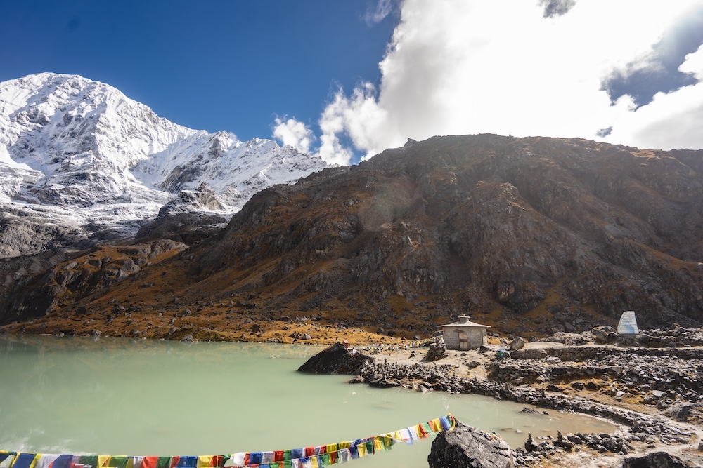
Dudhkunda is not only famous for its natural beauty but also attracts religious devotees. Many consider this place as the residence of Lord Shiva and express their reverence by coming here. During the Jaini Purnima festival, devotees from various places gather at Dudhkunda to fulfil their spiritual desires. At that time, people with faith in the belief that their wishes will be fulfilled come from various places. Before reaching Dudhkunda, there was also Bhootkunda, and after that, there was Ganga Jamuna Kund. The journey of those days had led us to liberation. As we got closer to Dudhkunda, the size and vastness of the Himalayas became more familiar. The more we approached, the more eager we became to gaze at Dudhkunda, which looked small compared to the surrounding smaller ponds and lakes.
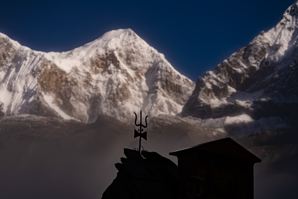
The Dudhkunda, situated at an altitude of 4600 metres above sea level, is a natural and religious site located in the Solukhumbu District. It falls under the Dudhkunda Rural Municipality and is a special place where the religious festival of Rakshabandhan, also known as Janai Purnima, is celebrated with a special fair. Around Dudhkunda, there are 105 other smaller ponds. According to mythology, when the deities were on their way to heaven from the Himalayas, they rested here for some time. Goddess Parvati, dropped a drop of milk that produced the pond. Hence, the pond is known as Dudhkunda, and this legend is widely accepted. However, when viewed closely, the water in the pond appears white, resembling milk. Another story tells that when Laxman, injured in the battle, needed the Sanjeevani herb, Hanuman came to this place for it. Unable to identify the herb, he uprooted a mountain, which is said to be in the vicinity. Such folk tales are also famous in this region.
Numbur Himal, with an elevation of 6,958 metres, is the prominent peak that can be seen from Dudhkunda. Additionally, the adjacent Khatang Himal, standing at an altitude of 6,582 metres, is also visible from Dudhkunda. Carrying the majesty of the surrounding Himalayas, including the famous Sagarmatha (Mount Everest) and other smaller peaks, the view from Dudhkunda encompasses not only Numbur Himal but also the grandeur of the entire Everest region.
There are other routes leading to Dudhkunda as well. The popular trekking route for the Mount Everest expedition passes through Lukla, and from there, you can trek to Dudhkunda. Another longer route involves a high-altitude trek with picturesque views. Passing through Ramechhap, Vanjhada Deurali, Sepduwa, Chhawar, Kaladanda, and Sanghifuk, following the Vasa Khola, you can reach Dudhkunda. Additionally, the Great Himalaya Trail, designed for experienced mountaineers, also leads to Dudhkunda along the same path. During the cold season, this area is often covered in snow. The pond itself may not be visible from a distance, but perhaps we arrived at the right time. Dudhkunda welcomed us with its serene beauty. The sky was clear, offering us a breathtaking view of the Himalayas. It felt like we were standing in the lap of the mountains. Though a bit challenging, the experience of reaching there and encountering the Himalayas was truly rewarding.
We had favourable weather throughout our journey, and Dudhkunda in front of us was tranquil, beautiful, and similarly enchanting. The touch of the Himalayan breeze was palpable in every corner. Overall, our expedition was a success. We hadn’t realized how close the Himalayas were until we covered a short distance. Sometimes, our minds need a break from the hustle and bustle of daily life. In the hustle and bustle of daily life, a short break is necessary. However, the desire and the achievement lie in the middle. In a brief respite from the daily grind, Dudhkunda offers an opportunity to explore the breathtaking landscapes, vibrant atmosphere, and creations of human imagination beyond the hustle and bustle. And Dudhkunda, with its boundless possibilities, shines like a sparkling star in the list of tourist destinations in Nepal. With various plant species, tourist potential, and the possibility of discovery from the source of a river to the remote corners visible from the Nepali perspective, Dudhkunda can be explored and admired up to the limit of difficulty or even beyond.

The journey is not devoid of the dilemma of what to leave behind and what to carry. Throughout our six-day expedition, we have accumulated many experiences. The first day took us to Okhaldhunga by bus, followed by the journey to Ringmu. From Ringmu, the trek took us to KamoDanda and then from KamoDanda to Saharsa Beni and finally Dudhkunda. We express our heartfelt gratitude to everyone who accompanied us on this journey, especially to our sponsors without whom this trip would not have been possible. Special thanks to the hotel operators who warmly hosted us throughout the journey, and to the porter who accompanied us from Ringmu. Also, thanks to all the viewers who, through their appreciation, have made this video a success and joined us in this journey. We will meet you again in another video. Until then, take care and enjoy your time until the next adventure.
Comments are closed.